Garmin eTrex Solar Owners Manual - Page 31
V Dist To Next
 |
View all Garmin eTrex Solar manuals
Add to My Manuals
Save this manual to your list of manuals |
Page 31 highlights
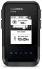
NONE: This is a blank data field. ODOMETER: A running tally of the distance traveled for all trips. This total does not clear when resetting the trip data. OFF COURSE: The distance to the left or right by which you have strayed from the original path of travel. You must be navigating for this data to appear. OVERALL AVG: The average speed while moving and stopped since the last reset. POINTER: An arrow points in the direction of the next waypoint or turn. You must be navigating for this data to appear. SOLAR INT: The intensity of solar input. SPEED: The current rate of travel. STOPPED TIME: The total time stopped for the current activity. STOPWATCH: The stopwatch time for the current activity. SUNRISE: The time of sunrise based on your GPS position. SUNRISE/SET: The time of the next sunrise or sunset based on your GPS position. SUNSET: The time of sunset based on your GPS position. TIME OF DAY: The time of day based on your current location and time settings (format, time zone, daylight saving time). TIME TO DEST: The estimated time remaining before you reach the destination. You must be navigating for this data to appear. TIME TO NEXT: The estimated time remaining before you reach the next waypoint in the route. You must be navigating for this data to appear. TO COURSE: The direction in which you must move to get back on the route. You must be navigating for this data to appear. TOTAL LAP: The stopwatch time for all the completed laps. TRIP ODOMETER: A running tally of the distance traveled since the last reset. TRIP TIME: A running tally of the total time spent moving and not moving since the last reset. TURN: The angle of difference (in degrees) between the bearing to your destination and your current course. L means turn left. R means turn right. You must be navigating for this data to appear. V DIST TO DEST: The elevation distance between your current position and the final destination. You must be navigating for this data to appear. V DIST TO NEXT: The elevation distance between your current position and the next waypoint in the route. You must be navigating for this data to appear. VEL MADE GOOD: The speed at which you are closing on a destination along a route. You must be navigating for this data to appear. VERTICAL SPEED: The rate of ascent or descent over time. VS TO DEST: The rate of ascent or descent to a predetermined altitude. You must be navigating for this data to appear. Appendix 27
-
 1
1 -
2
-
3
-
4
-
5
-
6
-
7
-
8
-
9
-
10
-
11
-
12
-
13
-
14
-
15
-
16
-
17
-
18
-
19
-
20
-
21
-
22
-
23
-
24
-
25
-
 26
26 -
 27
27 -
 28
28 -
 29
29 -
 30
30 -
 31
31 -
 32
32
 |
 |
