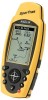
Magellan SporTrak User Manual - Page 16
For purposes of this manual, it will be, assumed that the receiver is in the marine mode.
 |
UPC - 763357103717
View all Magellan SporTrak manuals
Add to My Manuals
Save this manual to your list of manuals |
Page 16 highlights
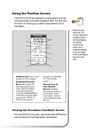
The following chart shows the terminology that your receiver uses while in land or marine mode. For purposes of this manual, it will be assumed that the receiver is in the marine mode. Speed Bearing Distance Heading Velocity Made Good Course To Steer Estimated Time of Arrival Time To Go Cross Track Error Recorded Position Units of Measure Land SPD BRG DST HDG VMG CTS ETA TTG XTE Landmark MILES/MPH or KM/KPH Marine SOG BRG DST COG VMG CTS ETA ETE XTE Waypoint NM/KNOTS You have completed the Initialization. The STATUS screen will appear on your receiver. STATUS 3D 12 13 N Note: The "3D" in the upper left corner is displayed when the receiver has begun computing your position. The "3D" symbol indicated 25 8 W W 18 7 that the receiver has acquired four or more satellites and can therefore compute elevation as well as your position. If "2D" is displayed, then the SporTrak is computing your position 001112 782385 POWER but not elevation. This could be either due to only three satellites have been acquired or you have set the elevation mode to 2D in the Setup Menu. 8 Magellan SporTrak
-
 1
1 -
2
-
3
-
4
-
5
-
6
-
7
-
8
-
9
-
10
-
 11
11 -
 12
12 -
 13
13 -
 14
14 -
 15
15 -
 16
16 -
 17
17 -
 18
18 -
 19
19 -
 20
20 -
 21
21 -
22
-
23
-
24
-
25
-
26
-
27
-
28
-
29
-
30
-
31
-
32
-
33
-
34
-
35
-
36
-
37
-
38
-
39
-
40
-
41
-
42
-
43
-
44
-
45
-
46
-
47
-
48
-
49
-
50
-
51
-
52
-
53
-
54
-
55
-
56
-
57
-
58
-
59
-
60
-
61
-
62
-
63
-
64
-
65
-
66
-
67
-
68
-
69
-
70
-
71
-
72
-
73
-
74
 |
 |