Magellan SporTrak User Manual - Page 73
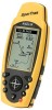
Magellan SporTrak
 |
UPC - 763357103717
View all Magellan SporTrak manuals
Add to My Manuals
Save this manual to your list of manuals |
Page 73 highlights
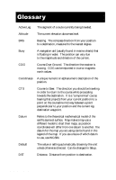
LMK Longitude Magnetic North NMEA OSGB Position fix SOG TRN True North TTG Magellan SporTrak Landmark. A location saved in the unit's memory which is obtained by entering data, editing data, calculating data or saving a current position. Used to create routes. Same as a waypoint. The angular distance east or west of the prime meridian (Greenwich Meridian) as measured by lines perpendicular to the parallels and converging at the poles from 0˚to 180˚. The direction relative to a magnetic compass National Marine Electronics Association. A professional organization that defines and maintains the standard serial format used by marine electronic navigation equipment and computer interfaces. A coordinate system describing only Great Britain, similar to UTMs. Used with GRB36 datum. Position coordinates as computed by the GPS receiver. Speed Over Ground. The speed at which the receiver is moving. Turn. Degrees or direction to turn. The direction to North Pole from an observer's position. The north direction on any geographical meridian. Time To Go. The measurement of how long it will take you to arrive at your destination. TTG is based on how fast you are moving towards the destination and the distance remaining. 65
-
 1
1 -
2
-
3
-
4
-
5
-
6
-
7
-
8
-
9
-
10
-
11
-
12
-
13
-
14
-
15
-
16
-
17
-
18
-
19
-
20
-
21
-
22
-
23
-
24
-
25
-
26
-
27
-
28
-
29
-
30
-
31
-
32
-
33
-
34
-
35
-
36
-
37
-
38
-
39
-
40
-
41
-
42
-
43
-
44
-
45
-
46
-
47
-
48
-
49
-
50
-
51
-
52
-
53
-
54
-
55
-
56
-
57
-
58
-
59
-
60
-
61
-
62
-
63
-
64
-
65
-
66
-
67
-
 68
68 -
 69
69 -
 70
70 -
 71
71 -
 72
72 -
 73
73 -
 74
74
 |
 |