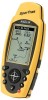
Magellan SporTrak User Manual - Page 72
Estimated Time of Arrival.
 |
UPC - 763357103717
View all Magellan SporTrak manuals
Add to My Manuals
Save this manual to your list of manuals |
Page 72 highlights
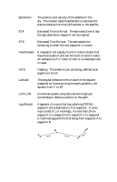
Ephemeris The position and velocity of the satellites in the sky. The receiver uses the ephemeris to calculate the precise distance from the GPS receiver to the satellite. ETA Estimated Time of Arrival. The estimated time of day the leg's destination waypoint will be reached. ETE Estimated Time Enroute. The estimated time remaining to reach the next waypoint in a route. Fixed Navaid A navigation aid (usually found in marine charts) that has a fixed position and can be found on land or water. An example is a T.V. tower on land or a Greenday mark in water. HDG Heading. The direction you are facing, defined as an angle from North. Latitude The angular distance north or south of the equator measured by lines encircling the earth parallel to the equator from 0˚ to 90˚. LAT/LON Coordinate system using latitude and longitude coordinates to define a position on the earth. Leg (Route) A segment of a route that has a starting (FROM) waypoint and a destination (TO) waypoint. A route may consist of 1 or more legs. A route that is from waypoint A to waypoint B to waypoint C to waypoint D has three legs with the first being from waypoint A to waypoint B. B A Leg 1 Leg 2 D Leg 3 C 64 Magellan SporTrak
-
 1
1 -
2
-
3
-
4
-
5
-
6
-
7
-
8
-
9
-
10
-
11
-
12
-
13
-
14
-
15
-
16
-
17
-
18
-
19
-
20
-
21
-
22
-
23
-
24
-
25
-
26
-
27
-
28
-
29
-
30
-
31
-
32
-
33
-
34
-
35
-
36
-
37
-
38
-
39
-
40
-
41
-
42
-
43
-
44
-
45
-
46
-
47
-
48
-
49
-
50
-
51
-
52
-
53
-
54
-
55
-
56
-
57
-
58
-
59
-
60
-
61
-
62
-
63
-
64
-
65
-
66
-
 67
67 -
 68
68 -
 69
69 -
 70
70 -
 71
71 -
 72
72 -
 73
73 -
 74
74
 |
 |