Magellan SporTrak User Manual - Page 54
Selecting a Coordinate System
 |
UPC - 763357103717
View all Magellan SporTrak manuals
Add to My Manuals
Save this manual to your list of manuals |
Page 54 highlights
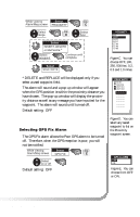
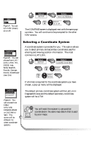
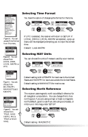
WPNTANVA1MES OOFFFF OONN Figure A. You can turn NAV screens on or off. Select SETUP FIG. A Select NAV SCREENS Select on or off The COMPASS screen is displayed next with the same popup menu. You will continue to be prompted for the other NAV screens. WCOPOTRNDAMSYESS OPRFFIMARY OSENCONDARY Figure B. You can choose from LAT/ LON, UTM, TD, OSGB, Irish, Swiss, Swedish, Finnish, German, French, MGRS and User Grid. Selecting a Coordinate System A coordinate system is provided for you. This option allows you to select primary and secondary coordinates used for entering and viewing position information. The most common is LAT/LON. Select SETUP Select COORD SYSTEM FIG. Select B system FIG. Select C format If a format is required for the coordinate system you have chosen, a pop-up menu will be displayed. WLPATTN/LAOMNES ODFEFG/MIN.MM ODNEG/MIN.MMM DEG/MIN/SEC Figure C. You can choose from DEG/ MIN.MM, DEGMIN.MMM or DEG/MIN/ SEC. The screen will be different for other coordinate systems. The default primary coordinate system will be Lat/Lon in Degrees/Minutes and the default secondary coordinate system will be UTM. You will want the receiver to use position coordinates in the same map datum that is used by your maps. 46 Magellan SporTrak
-
 1
1 -
2
-
3
-
4
-
5
-
6
-
7
-
8
-
9
-
10
-
11
-
12
-
13
-
14
-
15
-
16
-
17
-
18
-
19
-
20
-
21
-
22
-
23
-
24
-
25
-
26
-
27
-
28
-
29
-
30
-
31
-
32
-
33
-
34
-
35
-
36
-
37
-
38
-
39
-
40
-
41
-
42
-
43
-
44
-
45
-
46
-
47
-
48
-
 49
49 -
 50
50 -
 51
51 -
 52
52 -
 53
53 -
 54
54 -
 55
55 -
 56
56 -
 57
57 -
 58
58 -
 59
59 -
60
-
61
-
62
-
63
-
64
-
65
-
66
-
67
-
68
-
69
-
70
-
71
-
72
-
73
-
74
 |
 |