Magellan SporTrak User Manual - Page 26
Setting Track History, Clearing Track History, Selecting PAN-N-SCAN - review
 |
UPC - 763357103717
View all Magellan SporTrak manuals
Add to My Manuals
Save this manual to your list of manuals |
Page 26 highlights
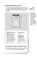
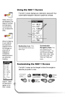
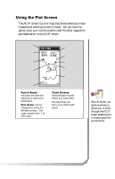
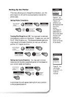
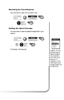
Selecting PAN-N-SCAN By using PAN-N-SCAN, you can look ahead or review where you have traveled according to waypoints, routes and track history. From PLOT screen Select PAN-N-SCAN The ARROWs can be used to move the cursor. If the cursor is over the waypoint icon when MENU is pressed, the menu will be displayed with WPT INFO added. Moving the cursor over a waypoint brings up the name, bearing and distance. Pressing MENU and selecting WPT INFO displays full information. In PAN-N-SCAN mode, you can zoom in by pressing the ENTER key. Once the lowest scale is reached (0.1 mile), pressing ENTER zooms out to the highest scale (200 miles). Setting Track History Using TRACK HISTORY records where you have been by automatically storing locations, as "dropping bread crumbs" from your starting point as you travel. This is useful when you want to return to your starting point. From PLOT screen Select TRACK HIST Change field Clearing Track History From PLOT screen Select CLR TRACK Select 18 Magellan SporTrak
-
 1
1 -
2
-
3
-
4
-
5
-
6
-
7
-
8
-
9
-
10
-
11
-
12
-
13
-
14
-
15
-
16
-
17
-
18
-
19
-
20
-
 21
21 -
 22
22 -
 23
23 -
 24
24 -
 25
25 -
 26
26 -
 27
27 -
 28
28 -
 29
29 -
 30
30 -
 31
31 -
32
-
33
-
34
-
35
-
36
-
37
-
38
-
39
-
40
-
41
-
42
-
43
-
44
-
45
-
46
-
47
-
48
-
49
-
50
-
51
-
52
-
53
-
54
-
55
-
56
-
57
-
58
-
59
-
60
-
61
-
62
-
63
-
64
-
65
-
66
-
67
-
68
-
69
-
70
-
71
-
72
-
73
-
74
 |
 |