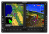
Garmin G500H G500H Cockpit Reference Guide
Garmin G500H Manual
 |
View all Garmin G500H manuals
Add to My Manuals
Save this manual to your list of manuals |
Garmin G500H manual content summary:
- Garmin G500H | G500H Cockpit Reference Guide - Page 1
G500H Cockpit Reference Guide - Garmin G500H | G500H Cockpit Reference Guide - Page 2
or its subsidiaries. All rights reserved. This manual reflects the operation of System Software version 3.00, or later. Some differences in operation may be observed when comparing the information in this manual to later software versions. Garmin International, Inc., 1200 East 151st Street, Olathe - Garmin G500H | G500H Cockpit Reference Guide - Page 3
service. To obtain warranty service, contact your local Garmin Authorized Service Center. For assistance in locating a Service Center near you, visit the Garmin web site at http://www.garmin.com or contact Garmin Customer Service at 800.800.1020. 190-01150-03 Rev B G500H Cockpit Reference Guide - Garmin G500H | G500H Cockpit Reference Guide - Page 4
. WARNING: The Garmin G500H has a very high degree of functional integrity. However, the pilot must recognize that providing monitoring and/ or self-test capability for all conceivable system failures is not practical. Although unlikely, it may be possible for erroneous operation to occur without - Garmin G500H | G500H Cockpit Reference Guide - Page 5
. WARNING: To reduce the risk of unsafe operation, carefully review and understand all aspects of the G500H Pilot's Guide. Thoroughly practice basic operation prior to actual use. During flight operations, carefully compare indications from the G500H to all available navigation sources, including the - Garmin G500H | G500H Cockpit Reference Guide - Page 6
parts. Repairs should only be made by an authorized Garmin service center. Unauthorized repairs or modifications could void both the warranty and pilot's authority to operate this device under FAA/FCC regulations. CAUTION: The G500H PFD and MFD displays use a lens coated with a special anti-reflective - Garmin G500H | G500H Cockpit Reference Guide - Page 7
not displayed when the aircraft latitude is greater than 75° North or 60° South. NOTE: Terrain-HSVT is standard when the Synthetic Vision Technology™ (SVT) option is installed. The HTAWS option will take precedence over Terrain-HSVT. WARNINGS, CAUTIONS, AND NOTES 190-01150-03 Rev B G500H Cockpit - Garmin G500H | G500H Cockpit Reference Guide - Page 8
Part Number 190-01150-03 Record of Revisions Revision Date Description A Jan 2010 Production Release B Mar 2010 Updated speed tape markings. vi G500H Cockpit Reference Guide 190-01150-03 Rev B - Garmin G500H | G500H Cockpit Reference Guide - Page 9
Warnings, Cautions, & Notes ii Introduction...1 Primary Flight Display (PFD 2 Airspeed Tape...4 Altitude Tape...5 33 Customizing the Weather Map 33 Displaying Surface Data and Winds Aloft 35 Aux Group ...36 External Video Page (Optional 36 190-01150-03 Rev B G500H Cockpit Reference Guide vii - Garmin G500H | G500H Cockpit Reference Guide - Page 10
Page (Optional) ...42 System Status Page ...44 Flight Plan Group 45 Active Flight Plan Page ...45 Viewing Your Active Flight Plan 45 Waypoint Information Page...46 Charts Page (Optional 56 Miscellaneous Symbols ...57 TABLE OF CONTENTS viii G500H Cockpit Reference Guide 190-01150-03 Rev B - Garmin G500H | G500H Cockpit Reference Guide - Page 11
to the system's operation. For more details on the G500H system, refer to the latest revision of the G500H Pilot's Guide, 190-01150-02. PRIMARY FLIGHT DISPLAY PFD/MFD NOTE: Some G500Hs have the right-side display configured as the PFD. 190-01150-03 Rev B G500H Cockpit Reference Guide 1 - Garmin G500H | G500H Cockpit Reference Guide - Page 12
PRIMARY FLIGHT DISPLAY PRIMARY FLIGHT DISPLAY (PFD) Primary Flight Display (PFD) 1 19 2 18 17 3 16 4 15 14 5 12 6 7 8 9 10 11 13 Primary Flight Display (PFD) 2 G500H Cockpit Reference Guide 190-01150-03 Rev B - Garmin G500H | G500H Cockpit Reference Guide - Page 13
MFD. 13 SD Card Slots, Upper and Lower: The upper slot is used for updating databases or software, the lower slot is for the database card. Soft Key Displays Current Altitude, Altitude Trend, Altitude Bug, Altitude Minimums Bug and BARO setting. 190-01150-03 Rev B G500H Cockpit Reference Guide - Garmin G500H | G500H Cockpit Reference Guide - Page 14
the pointer changes to red with white text. Overspeed VNE PRIMARY FLIGHT DISPLAY Airspeed Tape Markings Overspeed Indication Groundspeed Maximum (Vne) Speed with is selected during the installation configuration. True Airspeed Airspeed Tape 4 G500H Cockpit Reference Guide 190-01150-03 Rev B - Garmin G500H | G500H Cockpit Reference Guide - Page 15
PRIMARY FLIGHT DISPLAY PRIMARY FLIGHT DISPLAY (PFD) Altitude Tape The upper right portion of the PFD displays the Altitude Bug setting, BARO Setting Altitude Tape Barometric Pressure The Barometric Pressure (BARO setting) is displayed at the bottom of the altitude tape. To change the BARO setting - Garmin G500H | G500H Cockpit Reference Guide - Page 16
on the ground and also, if a value has been set for altitude alerting, until the aircraft reaches 150 feet above the setting for the alert. 6 G500H Cockpit Reference Guide 190-01150-03 Rev B - Garmin G500H | G500H Cockpit Reference Guide - Page 17
(PFD) To set the altitude for the Minimums Bug: PRIMARY FLIGHT DISPLAY 1) While viewing the Active Flight Plan page of the FPL Group, press the small MFD knob to activate the ft Within 200 ft Deviation of +/- 200ft Altitude Bug Indications 190-01150-03 Rev B G500H Cockpit Reference Guide 7 - Garmin G500H | G500H Cockpit Reference Guide - Page 18
DISPLAY PRIMARY FLIGHT DISPLAY (PFD) Wind Vectors The PFD will display a Wind Vector Field to the left of the HSI when configured by the user. There are four different styles of wind vector displays available. Refer to the System Setup page in the AUX Group section of this guide for instructions - Garmin G500H | G500H Cockpit Reference Guide - Page 19
ILS Approach Outside Air Temperature (OAT) The Outside Air Temperature, as sensed from the temperature probe on the aircraft, is displayed to the left of the HSI. This temperature is used in calculating the true airspeed. PRIMARY FLIGHT DISPLAY 190-01150-03 Rev B G500H Cockpit Reference Guide 9 - Garmin G500H | G500H Cockpit Reference Guide - Page 20
PRIMARY FLIGHT DISPLAY PRIMARY FLIGHT DISPLAY (PFD) Attitude Indicator Ground/Sky Pointer mode is configured during installation and can not be changed by the pilot. Scale G500H Attitude Indicator with a Sky Pointer Configuration in a Left Turn 10 G500H Cockpit Reference Guide 190-01150-03 Rev B - Garmin G500H | G500H Cockpit Reference Guide - Page 21
PRIMARY FLIGHT DISPLAY Current GPS Track Heading Trend HSI Heading Markings NOTE: If magnetic heading is lost, GPS ground track will be displayed in place of heading. If magnetic heading and GPS ground track are lost, a red "X" will appear in place of heading. 190-01150-03 Rev B G500H Cockpit - Garmin G500H | G500H Cockpit Reference Guide - Page 22
Additionally, ADF is available if an ADF source is installed. NAV2 Bearing Pointer NAV1 Bearing Pointer PRIMARY FLIGHT DISPLAY Selected source for BRG 1 bearing pointer Selected source for BRG 2 bearing pointer Bearing Pointers on the HSI 12 G500H Cockpit Reference Guide 190-01150-03 Rev B - Garmin G500H | G500H Cockpit Reference Guide - Page 23
message is displayed on the GNS. LOI (Loss of Integrity): Displays when GPS integrity is lost. Suspend OBS: Displays when OBS mode is activated. SUSP: Displays when automatic waypoint sequencing on the interfaced GPS unit is suspended. 190-01150-03 Rev B G500H Cockpit Reference Guide 13 - Garmin G500H | G500H Cockpit Reference Guide - Page 24
). NOTE: Verify the navigation source by the indication on the HSI. NOTE: The selected navigator is the active navigator for all the PFD and MFD operations, except for the supplemental bearing pointers. 14 G500H Cockpit Reference Guide 190-01150-03 Rev B - Garmin G500H | G500H Cockpit Reference Guide - Page 25
FLIGHT DISPLAY (PFD) Additional Features Garmin Terrain-HSVT™ (Optional) Garmin Terrain-HSVT is offered as an optional feature to the G500H. steps in "Displaying HSVT Terrain". NOTE: Airport Signs will only display airports, not heliports. 190-01150-03 Rev B G500H Cockpit Reference Guide 15 - Garmin G500H | G500H Cockpit Reference Guide - Page 26
FLIGHT DISPLAY PRIMARY FLIGHT DISPLAY (PFD) The following features are part of the Terrain-HSVT system. For more details refer to the latest revision of the G500H Pilot's Guide, 190-01150-02. • Flight Path Marker • Airport Signs • Horizon Heading Marks • Runway Display Displaying Garmin - Garmin G500H | G500H Cockpit Reference Guide - Page 27
the first page of the Map Group. 6 Menu: Displays configuration items for each page of the page groups. 7 Range Select: Changes the range on the map pages. Up arrow zooms out, down arrow zooms in. Also aids in scrolling up and down text pages. 190-01150-03 Rev B G500H Cockpit Reference Guide 17 - Garmin G500H | G500H Cockpit Reference Guide - Page 28
knob to change the highlighted value. 5) Press ENT to accept displayed value or press the small MFD knob to cancel selection or exit the editing mode. Default Map Page Press and hold the CLR key to return to the first page of the MAP group. 18 G500H Cockpit Reference Guide 190-01150-03 Rev B - Garmin G500H | G500H Cockpit Reference Guide - Page 29
soft keys available depend on the page displayed and the features available. The soft key Operate Alt Mode Below Normal Above Unrest Terrain Proximity OR Terrain-HSVT View View 360 Inhibit Arc RP Mode Mute Ctn AUX FPL External Video Video 1 Video B G500H Cockpit Reference Guide 19 - Garmin G500H | G500H Cockpit Reference Guide - Page 30
the map pointer is active, move the map pointer to highlight a waypoint. 2) Press ENT to display information about the highlighted waypoint. 3) Press the INFO soft key (if available) to view more the small MFD knob again to return to the map. 20 G500H Cockpit Reference Guide 190-01150-03 Rev B - Garmin G500H | G500H Cockpit Reference Guide - Page 31
distance, bearing, and coordinates are displayed at the top of the screen. Distance, Bearing and Coordinates Display Measuring Map Pointer 4) Press ENT to reset the distance and bearing values. 5) Press the small MFD knob to stop measuring. 190-01150-03 Rev B G500H Cockpit Reference Guide 21 - Garmin G500H | G500H Cockpit Reference Guide - Page 32
5) Turn the large MFD knob to move between fields. 6) Turn the small MFD knob to display available options. Press the ENT key to select your preference and move to the next option. 7) the map range below which the display feature will be visible. 22 G500H Cockpit Reference Guide 190-01150-03 Rev B - Garmin G500H | G500H Cockpit Reference Guide - Page 33
NM) • Other/Adiz (Range: Off to 500 NM) • TFR (Range: Off to 2500 NM) • Airways (Off, All, LO Only, HI Only) 190-01150-03 Rev B G500H Cockpit Reference Guide 23 - Garmin G500H | G500H Cockpit Reference Guide - Page 34
will show the external video on the top half of the MFD and a Navigation Map will be shown on the lower half. NOTE: The Map Display setup will be what is chosen for Navigation Map 1. TERRAIN, TOPO, and TRAFFIC can be turned off and on separately 24 G500H Cockpit Reference Guide 190-01150-03 Rev - Garmin G500H | G500H Cockpit Reference Guide - Page 35
-up window will be removed when the traffic alert is no longer active. Traffic Annunciation Traffic MAP GROUP: TRAFFIC PAGE Traffic Pop-Up PFD Traffic Display MFD Traffic Pop-Up Window 190-01150-03 Rev B G500H Cockpit Reference Guide 25 - Garmin G500H | G500H Cockpit Reference Guide - Page 36
viewing the Traffic Page of the Map Page Group press the OPERATE soft key to begin displaying traffic. "TAS OPERATING" is displayed in the Traffic mode field located in the upper left hand corner of the MFD. Traffic Mode Field Altitude Mode Field 26 G500H Cockpit Reference Guide 190-01150-03 Rev B - Garmin G500H | G500H Cockpit Reference Guide - Page 37
displayed. Pressing the BELOW, NORMAL, ABOVE or UNREST soft keys will determine what traffic is displayed Displays traffic from -9700 to +2700 ft Displays traffic from -2700 to +2700 ft Displays traffic from -2700 to +9700 ft All traffic is displayed the traffic pop-up is displayed on the MFD. After a few - Garmin G500H | G500H Cockpit Reference Guide - Page 38
when a Traffic Advisory System (TAS) is installed. Operating Mode MAP GROUP: TRAFFIC PAGE Traffic Advisory, aircraft is 800 feet above, climbing, and moving away Traffic Advisory, aircraft is 1000 feet below and moving away Traffic Map - TIS 28 G500H Cockpit Reference Guide 190-01150-03 Rev B - Garmin G500H | G500H Cockpit Reference Guide - Page 39
visual and aural alerting. Garmin TERRAIN-HSVT is provided with the Synthetic Vision functionality and not marketed separately. Garmin TERRAIN-HSVT is available in the GDU 620 v4.00 or later, when configured for Rotory Wing and SVT enabled. 190-01150-03 Rev B G500H Cockpit Reference Guide 29 - Garmin G500H | G500H Cockpit Reference Guide - Page 40
show Aviation Data Overlay on the Terrain page. You are also able to select the desired view. MAP GROUP: TERRAIN PAGE Aviation Data Overlay 30 G500H Cockpit Reference Guide 190-01150-03 Rev B - Garmin G500H | G500H Cockpit Reference Guide - Page 41
and exit. Menu Option Description Inhibit Terrain Does not display terrain warnings. Enable RP Mode Reduces the warning alerting thresholds Terrain Alerts Will display SVT Terrain shading if "Inhibit Terrain" is When Inhibited selected. 190-01150-03 Rev B G500H Cockpit Reference Guide 31 - Garmin G500H | G500H Cockpit Reference Guide - Page 42
is not displayed at the time, a pop-up alert appears on the MFD. To acknowledge the pop-up alert and return to the currently viewed page, press the CLR key. To acknowledge the pop-up alert and go to the TERRAIN-HSVT page, press the ENT key. 32 G500H Cockpit Reference Guide 190-01150 - Garmin G500H | G500H Cockpit Reference Guide - Page 43
viewing any of the WX Data Link Map pages in the WX Page Group, press the MENU key to display the Weather Setup Menu. Press ENT. 2) Turn the large MFD knob to select desired item to change. Turn WX Data Link Map page, press the small MFD knob. 190-01150-03 Rev B G500H Cockpit Reference Guide 33 - Garmin G500H | G500H Cockpit Reference Guide - Page 44
: Due to similarities in color schemes, it is not possible to display NEXRAD Data and Echo Top Data at the same time. NOTE: Due to similarities in color schemes, it is not possible to display Echo Top Data and Cloud Top Data at the same time. 34 G500H Cockpit Reference Guide 190-01150-03 Rev B - Garmin G500H | G500H Cockpit Reference Guide - Page 45
can be displayed on the , ENT button, or the small MFD knob. Displaying Surface Data and Winds Aloft Mini-Legend While viewing , if in the setup you chose to display SURFACE DATA VIEWING RANGE, the SRFC TIME Group, if in the setup you chose to display WINDS ALOFT DATA VIEWING RANGE, the WIND DOWN - Garmin G500H | G500H Cockpit Reference Guide - Page 46
MFD knob to exit out of the setup mode. Setting the Zoom Level of the Video Output Press the RNG (Range) keys to zoom in and out. The range of the zoom feature is 1x up to 10x. Video Soft Keys Setup Soft Key External Video Setup 36 G500H Cockpit Reference Guide 190-01150-03 Rev B - Garmin G500H | G500H Cockpit Reference Guide - Page 47
display. 3) Press ENT when you reach the desired level. NOTE: When LEVEL is changed, the MODE defaults to MANUAL. If MODE is set the AUTO, the LEVEL will adjust in response to ambient light or a lighting bus, as configured during installation . 190-01150-03 Rev B G500H Cockpit Reference Guide 37 - Garmin G500H | G500H Cockpit Reference Guide - Page 48
OFFSET. The date and time are coordinated with the GPS. 2) Turn the small MFD knob to display your choices of LOCAL 12hr, LOCAL 24hr, and UTC (Universal Time, Coordinated). Turn the small MFD See the table below to determine the time offset. 38 G500H Cockpit Reference Guide 190-01150-03 Rev B - Garmin G500H | G500H Cockpit Reference Guide - Page 49
move to the desired field of the MFD DISPLAY UNITS box. 2) Turn the small MFD knob to display your choices of FEET or METRIC units for altitude and vertical speed. Press ENT to confirm your selection. Press the small MFD knob to exit editing mode. 190-01150-03 Rev B G500H Cockpit Reference Guide 39 - Garmin G500H | G500H Cockpit Reference Guide - Page 50
to the desired field of the SYSTEM DISPLAY UNITS box. 2) Turn the small MFD knob to display your choices of CELSIUS(°C) or FAHRENHEIT(°F) for the temperature. Press ENT to confirm your selection and press the small MFD knob to exit editing mode. 40 G500H Cockpit Reference Guide 190-01150-03 Rev B - Garmin G500H | G500H Cockpit Reference Guide - Page 51
Page (Optional) Soft Key Found on XM Information Page While viewing the XM Information page of the Aux Group, turn the small MFD knob to display the XM Information screen. This page contains the Data Radio and Audio Radio IDs. The only option on this page is to LOCK in your - Garmin G500H | G500H Cockpit Reference Guide - Page 52
MFD knob to move to the desired channel. 4) Press ENT to make that channel the active channel. 5) Press the small MFD to end editing. 42 G500H Cockpit Reference Guide 190-01150-03 Rev B - Garmin G500H | G500H Cockpit Reference Guide - Page 53
, such as PS1. To move to the next group of presets, press the MORE soft key. AUX GROUP: XM RADIO PAGE 190-01150-03 Rev B G500H Cockpit Reference Guide 43 - Garmin G500H | G500H Cockpit Reference Guide - Page 54
are no menu options. In the LRU Status column, a green check means the unit is present and operating properly, while a red X indicates an absence or failure. This page is for informational purposes and there . Press the small MFD knob to exit. 44 G500H Cockpit Reference Guide 190-01150-03 Rev B - Garmin G500H | G500H Cockpit Reference Guide - Page 55
changes must be made from the GNS unit. FPL GROUP: ACTIVE FLIGHT PLAN Active Flight Plan Page 1) While viewing the Active Flight Plan page of the FPL Page Group, press the small MFD knob small MFD knob to return to the Active Flight Plan page. 190-01150-03 Rev B G500H Cockpit Reference Guide 45 - Garmin G500H | G500H Cockpit Reference Guide - Page 56
the INFO soft key to view information about the waypoint. 3) Press the WX soft key (if available) to view weather information for the waypoint. 46 G500H Cockpit Reference Guide 190-01150-03 Rev B - Garmin G500H | G500H Cockpit Reference Guide - Page 57
Day/Night View 1) While viewing the Charts page of the FPL Page Group, press the MENU key to display the Options menu. 2) Press ENT to go to Chart Setup. The Color Scheme option will be highlighted. is available when scroll bars are present. 190-01150-03 Rev B G500H Cockpit Reference Guide 47 - Garmin G500H | G500H Cockpit Reference Guide - Page 58
chart. 4) Press ENT to display the desired chart. NOTE: The chart for the selected destination airport or approach is automatically loaded. If the destination airport is in the flight plan, the chart page will default to the nearest airport. 48 G500H Cockpit Reference Guide 190-01150-03 Rev B - Garmin G500H | G500H Cockpit Reference Guide - Page 59
MFD knob to show FPL, NRST, or RECENT. 4) Turn the large MFD knob to highlight the desired airport, then press ENT. Display Charts From Flight Plan Display Charts Of Nearest Airport Display Charts From Recent Choices FPL GROUP: CHARTS PAGE 190-01150-03 Rev B G500H Cockpit Reference Guide 49 - Garmin G500H | G500H Cockpit Reference Guide - Page 60
in following ground control instructions by accurately displaying the aircraft position on the map in relation to taxiways, ramps, runways, terminals, and services. This database is updated available for viewing upon reaching the disable date. 50 G500H Cockpit Reference Guide 190-01150-03 Rev B - Garmin G500H | G500H Cockpit Reference Guide - Page 61
settings disagree. Failure of configuration module. Pilot stored data was lost. Recheck data and settings. System is in Diagnostic Mode. Cooling fan #1 or #2 has failed. Automated testing for specific LRU is corrupt. Specific LRU needs service. 190-01150-03 Rev B G500H Cockpit Reference Guide 51 - Garmin G500H | G500H Cockpit Reference Guide - Page 62
MANIFEST NAV1/2 FAIL SIMULATOR SVT DISABLED SW . Terrain DB resolution too low. GDU software version strings to no match. Xtalk is off. Airframe does not support terrain database. GPS1 TRK lost. HSI Obstacle" "Warning, Obstacle, Obstacle" ALERTS 52 G500H Cockpit Reference Guide 190-01150-03 Rev B - Garmin G500H | G500H Cockpit Reference Guide - Page 63
Serviced Airport Soft Surface, Serviced Airport Soft Surface, Non-serviced Airport Private Airport Heliport Intersection LOM (compass locator at outer marker) NDB (Non-directional Radio Beacon) VOR VOR/DME ILS/DME or DME-only VORTAC TACAN SYMBOLS 190-01150-03 Rev B G500H Cockpit Reference Guide - Garmin G500H | G500H Cockpit Reference Guide - Page 64
) Traffic Advisory (TA), In Range Traffic Advisory (TA), Out of Range Proximity Advisory (PA) Other Traffic On-Ground Aircraft Ground Non-Aircraft Vehicle SYMBOLS 54 G500H Cockpit Reference Guide 190-01150-03 Rev B - Garmin G500H | G500H Cockpit Reference Guide - Page 65
and Available Indicator Terrain Proximity Enabled and Not Available Indicator Traffic Enabled and Available Indicator Traffic Enabled and Not Available Indicator 190-01150-03 Rev B G500H Cockpit Reference Guide 55 - Garmin G500H | G500H Cockpit Reference Guide - Page 66
Echo Top Cloud Top XM Lightning Cell Movement SIGMETs / AIRMETs METARs City Forecast Surface Analysis Freezing Levels Winds Aloft County Warnings Cyclone Warnings SYMBOLS 56 G500H Cockpit Reference Guide 190-01150-03 Rev B - Garmin G500H | G500H Cockpit Reference Guide - Page 67
Turbine Helicopter Default Map Pointer Elevation Map Pointer User Waypoint Parallel Track Waypoint TFR (Temporary Flight Restrictions) Restricted/Prohibited/Warning/Alert MOA Class B Airspace Class C Airspace Class D Airspace SYMBOLS SYMBOLS 190-01150-03 Rev B G500H Cockpit Reference Guide 57 - Garmin G500H | G500H Cockpit Reference Guide - Page 68
This page intentionally left blank 58 G500H Cockpit Reference Guide 190-01150-03 Rev B - Garmin G500H | G500H Cockpit Reference Guide - Page 69
- Garmin G500H | G500H Cockpit Reference Guide - Page 70
Kansas 66062, U.S.A. Tel. 913/397.8200 or 800/800.1020 Fax 913/397.8282 Garmin AT, Inc. 2345 Turner Rd., SE, Salem, Oregon 97302, U.S.A. Tel. 503/581.8101 or 800/525.6726 Fax. 503/364.2138 Garmin (Europe) Ltd. Liberty House, Bulls Copse Road, Hounsdown Business Park, Southampton, SO40 9RB, U.K. Tel
-
 1
1 -
 2
2 -
 3
3 -
 4
4 -
 5
5 -
 6
6 -
 7
7 -
8
-
9
-
10
-
11
-
12
-
13
-
14
-
15
-
16
-
17
-
18
-
19
-
20
-
21
-
22
-
23
-
24
-
25
-
26
-
27
-
28
-
29
-
30
-
31
-
32
-
33
-
34
-
35
-
36
-
37
-
38
-
39
-
40
-
41
-
42
-
43
-
44
-
45
-
46
-
47
-
48
-
49
-
50
-
51
-
52
-
53
-
54
-
55
-
56
-
57
-
58
-
59
-
60
-
61
-
62
-
63
-
64
-
65
-
66
-
67
-
68
-
69
-
70
 |
 |

G500H
Cockpit
Reference Guide