Garmin G500H G500H Cockpit Reference Guide - Page 38
TIS Traffic, Displaying TIS Traffic, OPERATE
 |
View all Garmin G500H manuals
Add to My Manuals
Save this manual to your list of manuals |
Page 38 highlights
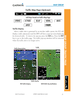
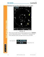
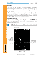
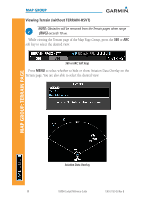
MAP GROUP TIS Traffic The Traffic Map Page is configured to show surrounding TIS traffic data in relation to the aircraft's current position and altitude, without clutter from the basemap. Aircraft orientation on this map is always heading up unless there is no valid heading. TIS receives traffic information from ground stations, and is updated every five seconds. The G500H displays up to eight traffic targets within a 7.5-NM radius, from 3000 feet below to 3500 feet above the requesting aircraft. Traffic is displayed according to TCAS symbology using four different symbols. Displaying TIS Traffic While viewing the Traffic Page of the Map Page Group press the OPERATE soft key to begin displaying traffic. "TIS OPERATING" is displayed in the upper left hand corner of the MFD. NOTE: TIS is disabled when a Traffic Advisory System (TAS) is installed. Operating Mode MAP GROUP: TRAFFIC PAGE Traffic Advisory, aircraft is 800 feet above, climbing, and moving away Traffic Advisory, aircraft is 1000 feet below and moving away Traffic Map - TIS 28 G500H Cockpit Reference Guide 190-01150-03 Rev B
-
 1
1 -
2
-
3
-
4
-
5
-
6
-
7
-
8
-
9
-
10
-
11
-
12
-
13
-
14
-
15
-
16
-
17
-
18
-
19
-
20
-
21
-
22
-
23
-
24
-
25
-
26
-
27
-
28
-
29
-
30
-
31
-
32
-
 33
33 -
 34
34 -
 35
35 -
 36
36 -
 37
37 -
 38
38 -
 39
39 -
 40
40 -
 41
41 -
 42
42 -
 43
43 -
44
-
45
-
46
-
47
-
48
-
49
-
50
-
51
-
52
-
53
-
54
-
55
-
56
-
57
-
58
-
59
-
60
-
61
-
62
-
63
-
64
-
65
-
66
-
67
-
68
-
69
-
70
 |
 |
