Garmin G500H G500H Cockpit Reference Guide - Page 44
Weather Items
 |
View all Garmin G500H manuals
Add to My Manuals
Save this manual to your list of manuals |
Page 44 highlights
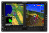
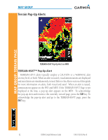
WX GROUP: DATA LINK PAGES WX GROUP Weather Items WX Page Menu - Weather Setup Menu Item Selections Available Map Orientation NEXRAD Data Viewing Range NEXRAD Legend North Up, Track Up Range: Off, 10 NM to 2000 NM On, Off Echo Top Data Viewing Range Cloud Top Data Viewing Range Lightning Data Viewing Range Cell Mov Data Viewing Range SIG/Air Viewing Range METAR Data Viewing Range Surface Data Viewing Range Surface Data Time Frz Lvl Data Viewing Range Winds Aloft Data Viewing Range Winds Aloft Altitude County Data Viewing Range Cyclone Data Viewing Range Range: Off, 10 NM to 2000 NM Range: Off, 10 NM to 2000 NM Range: Off, 10 NM to 2000 NM Range: Off, 10 NM to 2000 NM Range: Off, 10 NM to 2000 NM Range: Off, 500 FT to 2000 NM Range: Off, 10 NM to 2000 NM Range: Current, 12 HR to 48 HR Range: Off, 10 NM to 2000 NM Range: Off, 10 NM to 2000 NM Range: Surface, 3000 FT to 42000 FT Range: Off, 10 NM to 2000 NM On, Off NOTE: Due to similarities in color schemes, it is not possible to display NEXRAD Data and Echo Top Data at the same time. NOTE: Due to similarities in color schemes, it is not possible to display Echo Top Data and Cloud Top Data at the same time. 34 G500H Cockpit Reference Guide 190-01150-03 Rev B
-
 1
1 -
2
-
3
-
4
-
5
-
6
-
7
-
8
-
9
-
10
-
11
-
12
-
13
-
14
-
15
-
16
-
17
-
18
-
19
-
20
-
21
-
22
-
23
-
24
-
25
-
26
-
27
-
28
-
29
-
30
-
31
-
32
-
33
-
34
-
35
-
36
-
37
-
38
-
 39
39 -
 40
40 -
 41
41 -
 42
42 -
 43
43 -
 44
44 -
 45
45 -
 46
46 -
 47
47 -
 48
48 -
 49
49 -
50
-
51
-
52
-
53
-
54
-
55
-
56
-
57
-
58
-
59
-
60
-
61
-
62
-
63
-
64
-
65
-
66
-
67
-
68
-
69
-
70
 |
 |
