Garmin G500H G500H Cockpit Reference Guide - Page 31
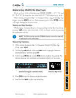
Decluttering DCLTR the Map s
 |
View all Garmin G500H manuals
Add to My Manuals
Save this manual to your list of manuals |
Page 31 highlights
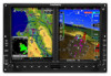
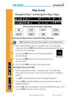
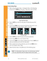
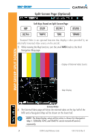
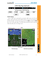
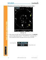
MAP GROUP: NAV PAGES MAP GROUP Decluttering (DCLTR) the Map Pages There are four levels of decluttering, DCLTR, DCLTR-1, DCLTR-2, and DCLTR-3. DCLTR shows the most detail while DCLTR-3 removes most detail. While viewing Navigation Map 1 or Navigation Map 2 page of the Map Page Group, press the DCLTR soft key. Each successive press of the DCLTR soft key will toggle through the declutter levels. Turning on Map Overlays While viewing Navigation Map 1 or Navigation Map 2 of the Map Page Group, press the MAP soft key. Select the Traffic, TOPO, or Terrain overlays by pressing the appropriate soft key. NOTE: The TOPO overlay and the TERRAIN overlay cannot be selected or displayed on the same page. Measuring Distances 1) While viewing Navigation Map 1 or Navigation Map 2 of the Map Page Group, press MENU. 2) Turn the large MFD knob or the small MFD knob to highlight "Measure Bearing/Distance" and then press ENT. 3) Turn the large MFD knob or small MFD knob to move the map pointer. The distance, bearing, and coordinates are displayed at the top of the screen. Distance, Bearing and Coordinates Display Measuring Map Pointer 4) Press ENT to reset the distance and bearing values. 5) Press the small MFD knob to stop measuring. 190-01150-03 Rev B G500H Cockpit Reference Guide 21
-
 1
1 -
2
-
3
-
4
-
5
-
6
-
7
-
8
-
9
-
10
-
11
-
12
-
13
-
14
-
15
-
16
-
17
-
18
-
19
-
20
-
21
-
22
-
23
-
24
-
25
-
 26
26 -
 27
27 -
 28
28 -
 29
29 -
 30
30 -
 31
31 -
 32
32 -
 33
33 -
 34
34 -
 35
35 -
 36
36 -
37
-
38
-
39
-
40
-
41
-
42
-
43
-
44
-
45
-
46
-
47
-
48
-
49
-
50
-
51
-
52
-
53
-
54
-
55
-
56
-
57
-
58
-
59
-
60
-
61
-
62
-
63
-
64
-
65
-
66
-
67
-
68
-
69
-
70
 |
 |
