Garmin G500H G500H Cockpit Reference Guide - Page 39
Map Group: Terrain - synthetic vision
 |
View all Garmin G500H manuals
Add to My Manuals
Save this manual to your list of manuals |
Page 39 highlights
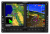
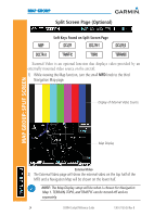
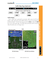
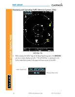
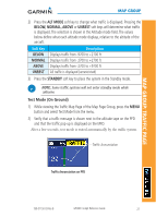
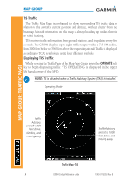
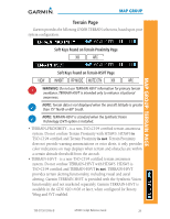
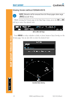
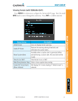
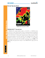
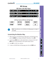
MAP GROUP Terrain Page Garmin provides the following G500H TERRAIN selections, based upon your system configuration. Soft Keys Found on Terrain Proximity Page MAP GROUP: TERRAIN PAGE Soft Keys Found on Terrain-HSVT Page WARNING: Do not use TERRAIN-HSVT information for primary terrain avoidance. TERRAIN-HSVT is intended only to enhance situational awareness. NOTE: Terrain data is not displayed when the aircraft latitude is greater than 75° North or 60° South. NOTE: TERRAIN-HSVT is standard when the Synthetic Vision Technology (SVT) option is installed. • TERRAIN-PROXIMITY - is a non-TSO-C194 certified terrain awareness system. Do not confuse Terrain Proximity with HTAWS. HTAWS is TSO-C194 certified and Terrain Proximity is not. Terrain Proximity does not provide warning annunciations or voice alerts, it only provides color indications on map displays when terrain and obstacles are within a certain altitude threshold from the aircraft. • TERRAIN-HSVT - is a non-TSO-C194 certified terrain awareness system. Do not confuse TERRAIN-HSVT with HTAWS. HTAWS is TSO-C194 certified and TERRAIN-HSVT is not. TERRAIN-HSVT provides terrain alerting functionality, including visual and aural alerting. Garmin TERRAIN-HSVT is provided with the Synthetic Vision functionality and not marketed separately. Garmin TERRAIN-HSVT is available in the GDU 620 v4.00 or later, when configured for Rotory Wing and SVT enabled. 190-01150-03 Rev B G500H Cockpit Reference Guide 29
-
 1
1 -
2
-
3
-
4
-
5
-
6
-
7
-
8
-
9
-
10
-
11
-
12
-
13
-
14
-
15
-
16
-
17
-
18
-
19
-
20
-
21
-
22
-
23
-
24
-
25
-
26
-
27
-
28
-
29
-
30
-
31
-
32
-
33
-
 34
34 -
 35
35 -
 36
36 -
 37
37 -
 38
38 -
 39
39 -
 40
40 -
 41
41 -
 42
42 -
 43
43 -
 44
44 -
45
-
46
-
47
-
48
-
49
-
50
-
51
-
52
-
53
-
54
-
55
-
56
-
57
-
58
-
59
-
60
-
61
-
62
-
63
-
64
-
65
-
66
-
67
-
68
-
69
-
70
 |
 |
