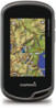
Garmin Oregon 650 Owner's Manual - Page 19
Data Fields - reset
 |
View all Garmin Oregon 650 manuals
Add to My Manuals
Save this manual to your list of manuals |
Page 19 highlights
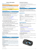
to ambient air, and therefore, provides a consistent source of accurate temperature data. You must pair the tempe with your device to display temperature data from the tempe. Data Fields Some data fields require you to be navigating or require ANT + accessories to display data. 24hr Max Temperature: The maximum temperature recorded in the last 24 hours. 24hr Min Temperature: The minimum temperature recorded in the last 24 hours. Accuracy Of GPS: The margin of error for your exact location. For example, your GPS location is accurate to within +/- 12 feet (3. 65 m). Alarm Timer: The current time of the countdown timer. Ambient Pressure: The uncalibrated environmental pressure. Ascent - Average: The average vertical distance of ascent since the last reset. Ascent - Maximum: The maximum rate of ascent in feet per minute or meters per minute since the last reset. Ascent - Total: The total elevation distance ascended since the last reset. Automotive Turn: The direction of the next turn in the route. You must be navigating for this data to appear. Average Cadence: The average cadence for the current activity. Average Heart Rate: The average heart rate for the current activity. Average Lap: The average lap time for the current activity. Avg. Heart Rate Percent: The average percentage of maximum heart rate for the current activity. Barometer: The calibrated current pressure. Battery Level: The remaining battery power. Bearing: The direction from your current location to a destination. You must be navigating for this data to appear. Cadence: The revolutions of the crank arm or strides per minute. Your device must be connected to a cadence accessory. Calories: The amount of total calories burned. Compass Heading: The direction the device is pointing based on the compass. Course: The direction from your starting location to a destination. Course can be viewed as a planned or set route. You must be navigating for this data to appear. Current Lap: The stopwatch time for the current lap. Date: The current day, month, and year. Depth: The depth of the water. Your device must be connected to a NMEA 0183 device capable of acquiring the water depth. Descent - Average: The average vertical distance of descent since the last reset. Descent - Maximum: The maximum rate of descent in feet per minute or meters per minute since the last reset. Descent - Total: The total elevation distance descended since the last reset. Distance To Destination: The remaining distance to the final destination. You must be navigating for this data to appear. Distance To Next: The remaining distance to the next waypoint on the route. You must be navigating for this data to appear. Elapsed (Total) Time: The total time recorded. For example, if you start the timer and run for 10 minutes, then stop the timer for 5 minutes, then start the timer and run for 20 minutes, your elapsed time is 35 minutes. Elevation: The altitude of your current location above or below sea level. Elevation Above Ground: The altitude of your current location above ground level. Elevation - Maximum: The highest elevation reached since the last reset. Elevation - Minimum: The lowest elevation reached since the last reset. ETA At Destination: The estimated time of day you will reach the final destination (adjusted to the local time of the destination). You must be navigating for this data to appear. ETA At Next: The estimated time of day you will reach the next waypoint on the route (adjusted to the local time of the waypoint). You must be navigating for this data to appear. Glide Ratio: The ratio of horizontal distance traveled to the change in vertical distance. Glide Ratio To Dest: The glide ratio required to descend from your current position to the destination elevation. You must be navigating for this data to appear. GPS Elevation: The altitude of your current location using GPS. GPS Heading: The direction you are moving based on GPS. GPS Signal Strength: The strength of the GPS satellite signal. Grade: The calculation of rise (elevation) over run (distance). For example, if for every 10 feet (3 m) you climb you travel 200 feet (60 m), the grade is 5%. Heading: The direction you are moving. Heart Rate: Your heart rate in beats per minute (bpm). Your device must be connected to a compatible heart rate monitor. Heart Rate Percent Max: The percentage of maximum heart rate. Heart Rate Zone: The current range of heart rate (1 to 5). The default zones are based on your user profile, maximum heart rate, and resting heart rate. Lap Ascent: The vertical distance of ascent for the current lap. Lap Cadence: The average cadence for the current lap. Lap Descent: The vertical distance of descent for the current lap. Lap Distance: The distance traveled for the current lap. Lap Heart Rate: The average heart rate for the current lap. Lap Heart Rate Percent: The average percentage of maximum heart rate for the current lap. Laps: The number of laps completed for the current activity. Lap Speed: The average speed for the current lap. Last Lap Ascent: The vertical distance of ascent for the last completed lap. Last Lap Cadence: The average cadence for the last completed lap. Last Lap Descent: The vertical distance of descent for the last completed lap. Last Lap Distance: The distance traveled for the last completed lap. Last Lap Heart Rate: The average heart rate for the last completed lap. Last Lap Speed: The average speed for the last completed lap. Last Lap Time: The stopwatch time for the last completed lap. Location (lat/lon): The current position in latitude and longitude regardless of the selected position format setting. Location (selected): The current position using the selected position format setting. Appendix 15
-
 1
1 -
2
-
3
-
4
-
5
-
6
-
7
-
8
-
9
-
10
-
11
-
12
-
13
-
 14
14 -
 15
15 -
 16
16 -
 17
17 -
 18
18 -
 19
19 -
 20
20 -
 21
21 -
 22
22
 |
 |