Garmin Oregon 650 Owner's Manual - Page 9
Navigating with the Compass, Navigating with Sight 'N Go, Elevation Plot, Trip Computer, Taking - oregon 650t manual
 |
View all Garmin Oregon 650 manuals
Add to My Manuals
Save this manual to your list of manuals |
Page 9 highlights
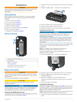
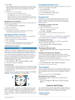
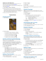
2 Select Map. A blue triangle represents your location on the map. As you travel, the blue triangle moves and leaves a track log (trail). You can change how the track log appears on the map (page 3). 3 Complete one or more actions: • Drag the map to view different areas. • Select and to zoom in and out of the map. • Select a location on the map (represented by a pin), and select the information bar at the top of the screen to view information about the selected location. Navigating a Driving Route Before you can navigate street routes, you must purchase and load City Navigator maps. 1 Select Profile Change > Automotive. 2 Select a destination. 3 Navigate using the map. Turns appear in the text bar along the top of the map. Audible tones signal turns in the route. Navigating with the Compass When navigating to a destination, points to your destination, regardless of the direction you are moving. 1 Begin navigating to a destination (page 4). 2 Select Compass. 3 Turn until points toward the top of the compass, and continue moving in that direction to the destination. Calibrating the Compass NOTICE Calibrate the electronic compass outdoors. To improve heading accuracy, do not stand near objects that influence magnetic fields, such as vehicles, buildings, and overhead power lines. Your device was already calibrated at the factory, and the device uses automatic calibration by default. If you experience irregular compass behavior, for example, after moving long distances or after extreme temperature changes, you can manually calibrate the compass. 1 Select Compass > > Calibrate Compass > Start. 2 Follow the on-screen instructions. Course Pointer The course pointer is most useful if you are navigating on water or where there are no major obstacles in your path. It also helps you avoid hazards to either side of the course, such as shoals or submerged rocks. To enable the course pointer, from the compass, select Setup > Heading > Go To Line/Pointer > Course (CDI). Navigating with Sight 'N Go You can point the device at an object in the distance, lock in the direction, and navigate to the object. 1 Select Sight 'N Go. 2 Point the device at an object. 3 Select Lock Direction > Set Course. 4 Navigate using the compass. Elevation Plot By default, the elevation plot displays the elevation over the distance traveled. To customize the elevation settings, see page 11. You can touch any point on the plot to view details about that point. Navigating to a Point on the Plot 1 Select Elevation Plot. 2 Select an individual point on the plot. Details about the point appear. 3 Select > View Map. 4 Select the information bar at the top of the screen. 5 Select Go. The map opens with your route marked with a magenta line. 6 Navigate using the map (page 4) or compass (page 5). Changing the Plot Type You can change the elevation plot to display pressure and elevation over time or distance. 1 Select Elevation Plot > Change Plot Type. 2 Select an option. Resetting the Elevation Plot Select Elevation Plot > > Reset > Clear Current Track > Clear. Calibrating the Barometric Altimeter Your device was already calibrated at the factory, and the device uses automatic calibration by default. You can manually calibrate the barometric altimeter if you know the correct elevation or the correct barometric pressure. 1 Go to a location where the elevation or barometric pressure is known. 2 Select Elevation Plot > > Calibrate Altimeter. 3 Follow the on-screen instructions. Trip Computer The trip computer displays your current speed, average speed, maximum speed, trip odometer, and other helpful statistics. You can customize the trip computer layout, dashboard, and data fields. From the main menu, select Trip Computer. Resetting the Trip Computer For accurate information, reset the trip information before beginning a trip. Select Trip Computer > > Reset > Reset Trip Data > Reset. The course pointer indicates your relationship to the course À line leading to the destination. The course deviation indicator (CDI) provides the indication of drift (right or left) from the  course. The scale refers to the distance between dots on Á à the course deviation indicator, which tell you how far off course you are. Camera and Photos Camera and Photos You can take photos with the Oregon 650 and 650t. When you take a photo, the geographic location is automatically saved in the photo information. You can navigate to the location. Taking a Photo 1 Select Camera. 5
-
 1
1 -
2
-
3
-
 4
4 -
 5
5 -
 6
6 -
 7
7 -
 8
8 -
 9
9 -
 10
10 -
 11
11 -
 12
12 -
 13
13 -
 14
14 -
15
-
16
-
17
-
18
-
19
-
20
-
21
-
22
 |
 |