Table of Contents
Introduction
....................................................................
1
Getting Started
...........................................................................
1
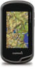
Device Overview
........................................................................
1
Battery Information
.....................................................................
1
Installing the NiMH Battery Pack
...........................................
1
Installing AA Batteries
...........................................................
1
Turning On the Device
...............................................................
2
Acquiring Satellites Signals and Recording a Track
.............
2
Using the Touchscreen
.........................................................
2
Waypoints, Routes, and Tracks
...................................
2
Waypoints
..................................................................................
2
Creating a Waypoint
..............................................................
2
Marking a Waypoint Using the Map
......................................
2
Finding a Waypoint
...............................................................
2
Editing a Waypoint
................................................................
2
Deleting a Waypoint
..............................................................
2
Increasing the Accuracy of a Waypoint Location
..................
2
Projecting a Waypoint
...........................................................
2
Where To? Menu
.......................................................................
3
Optional Maps
.......................................................................
3
Finding a Location by Name
.................................................
3
Finding a Location Near Another Location
............................
3
Finding an Address
...............................................................
3
Routes
........................................................................................
3
Creating a Route
...................................................................
3
Editing the Name of a Route
.................................................
3
Editing a Route
......................................................................
3
Viewing a Route on the Map
.................................................
3
Deleting a Route
...................................................................
3
Viewing the Active Route
......................................................
3
Reversing a Route
................................................................
3
Tracks
........................................................................................
3
Recording a Track Log
..........................................................
3
Customizing Your Track Log
.................................................
3
Navigating Using TracBack®
................................................
3
Saving the Current Track
......................................................
4
Viewing Track Information
.....................................................
4
Viewing the Elevation Plot of a Track
....................................
4
Saving a Location on a Track
................................................
4
Changing the Track Color
.....................................................
4
Archiving Saved Tracks
........................................................
4
Clearing the Current Track
....................................................
4
Deleting a Track
....................................................................
4
Garmin Adventures
....................................................................
4
Sending Files to BaseCamp
..................................................
4
Creating an Adventure
..........................................................
4
Starting an Adventure
...........................................................
4
Navigation
.......................................................................
4
Navigating to a Destination
........................................................
4
Stopping Navigation
..............................................................
4
Marking and Starting Navigation to a Man Overboard
Location
.....................................................................................
4
Navigating with the Map
.............................................................
4
Navigating a Driving Route
...................................................
5
Navigating with the Compass
....................................................
5
Calibrating the Compass
.......................................................
5
Course Pointer
......................................................................
5
Navigating with Sight 'N Go
.......................................................
5
Elevation Plot
.............................................................................
5
Navigating to a Point on the Plot
...........................................
5
Changing the Plot Type
.........................................................
5
Resetting the Elevation Plot
..................................................
5
Calibrating the Barometric Altimeter
.....................................
5
Trip Computer
............................................................................
5
Resetting the Trip Computer
.................................................
5
Camera and Photos
.......................................................
5
Taking a Photo
...........................................................................
5
Viewing Photos
..........................................................................
6
Viewing a Slideshow
.............................................................
6
Sorting Photos
.......................................................................
6
Viewing the Location of a Photo
............................................
6
Setting a Photo as Wallpaper
................................................
6
Deleting a Photo
....................................................................
6
Navigating to a Photo
............................................................
6
Geocaches
......................................................................
6
Downloading Geocaches
...........................................................
6
Filtering the Geocache List
........................................................
6
Creating and Saving a Geocache Filter
................................
6
Editing a Custom Geocache Filter
........................................
6
Navigating to a Geocache
..........................................................
6
Logging the Attempt
...................................................................
6
chirp™
........................................................................................
6
Enabling chirp Searching
......................................................
6
Finding a Geocache with a chirp
...........................................
7
Fitness
............................................................................
7
Running or Cycling with Your Device
.........................................
7
History
........................................................................................
7
Viewing an Activity
................................................................
7
Deleting an Activity
................................................................
7
Using Garmin Connect
..........................................................
7
Optional Fitness Accessories
.....................................................
7
Pairing Your ANT+ Sensors
..................................................
7
Tips for Pairing ANT+ Accessories with Your Garmin
Device
...................................................................................
7
About Heart Rate Zones
............................................................
7
Fitness Goals
........................................................................
7
Setting Your Heart Rate Zones
.............................................
8
Applications
...................................................................
8
Using the 3D View
.....................................................................
8
Sending and Receiving Data Wirelessly
....................................
8
Setting a Proximity Alarm
...........................................................
8
Using the Flashlight
...................................................................
8
Calculating the Size of an Area
..................................................
8
Using the Calculator
...................................................................
8
Viewing the Calendar and Almanacs
.........................................
8
Setting an Alarm
........................................................................
8
Starting the Countdown Timer
...................................................
8
Opening the Stopwatch
..............................................................
9
Satellite Page
.............................................................................
9
Changing the Satellite View
..................................................
9
Turning Off GPS
....................................................................
9
Simulating a Location
............................................................
9
Customizing the Device
................................................
9
Adjusting the Backlight Brightness
.............................................
9
Main Menu
.................................................................................
9
Customizing the Main Menu
..................................................
9
Locking the Touchscreen
......................................................
9
Rotating the Screen
..............................................................
9
Locking the Screen Orientation
.............................................
9
Creating a Shortcut
...............................................................
9
Adding a Shortcut to the Main Menu
.....................................
9
Custom Data Fields and Dashboards
........................................
9
Enabling the Map Data Fields
...............................................
9
Customizing the Data Fields
...............................................
10
Customizing Dashboards
....................................................
10
Profiles
.....................................................................................
10
Selecting a Profile
...............................................................
10
Table of Contents
i
 1
1 2
2 3
3 4
4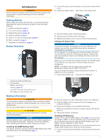 5
5 6
6 7
7 8
8 9
9