Garmin GMX 200 Pilots Guide - Page 23
Zoom Level, Obstructions, Ownship, Terrain, Traffic - ads b
 |
View all Garmin GMX 200 manuals
Add to My Manuals
Save this manual to your list of manuals |
Page 23 highlights
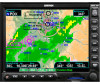
Getting Started Advisory Hot Key Thumbnail Feature The Thumbnail feature provides a small map depiction that is overlaid in the upper left corner of the GMX 200 display. It provides for enhanced traffic and terrain situational awareness when not specifically viewing traffic or terrain related functions. For example, both traffic and terrain situational awareness can be maintained while viewing the Flight Plan Function. Obstructions Traffic Ownship Terrain Zoom Level Thumbnail view of conflicting terrain and traffic The Thumbnail is shown in both a small and large format, depending on the function currently being viewed. The Thumbnail is typically presented in the larger format when overlaid on a map. However, on some functions where the Thumbnail would overlay critical information, the smaller format is utilized. The Thumbnail provides a fixed 5 NM range view with a solid circle and a 2 NM inner circle. The range depicted by the Thumbnail is not affected by the current zoom scale set on the main map functions. Traffic on Thumbnail TIS, TAS, TCAS, or ADS-B traffic is shown on the Thumbnail in the same symbology used within the Traffic Function. Any traffic within sensor range and 5 NM is shown, in addition to traffic causing an amber Traffic Alert (TA) traffic. Note that the GMX 200 supports one traffic sensor in any installation. Terrain on the Thumbnail Only "Red" terrain within the 5 NM range is presented on the Thumbnail. This correlates directly to terrain that is rendered in red on the normal Terrain Function based on the internal terrain database. External TAWS-based terrain from the Goodrich Landmark is not shown on the Thumbnail. Obstructions on the Thumbnail Only "Red" obstructions within the 5 NM range are presented on the Thumbnail. This correlates directly to obstructions that are rendered in red on the other functions. Thumbnail Activation The Thumbnail incorporates logic that will either show or hide the thumbnail from view. It will only be shown when there is data to be presented and will be removed if not. For example, if there is no "Red" terrain or traffic within 5 NM, the Thumbnail will be hidden from view. The Thumbnail will not appear on the Traffic Function page if only traffic would be presented in the Thumbnail. Correspondingly, it is not shown on the Terrain page if only terrain would be presented in the Thumbnail. This logic eliminates redundant views that would be created by the Thumbnail and normal views of traffic and terrain. Additionally, the Thumbnail is disabled while operating on the ground. This state is determined by the "En Route/ Ground Transition Speed" set in the System Function page and is based on GPS ground speed. 190-00607-02 Rev C 11
-
 1
1 -
2
-
3
-
4
-
5
-
6
-
7
-
8
-
9
-
10
-
11
-
12
-
13
-
14
-
15
-
16
-
17
-
 18
18 -
 19
19 -
 20
20 -
 21
21 -
 22
22 -
 23
23 -
 24
24 -
 25
25 -
 26
26 -
 27
27 -
 28
28 -
29
-
30
-
31
-
32
-
33
-
34
-
35
-
36
-
37
-
38
-
39
-
40
-
41
-
42
-
43
-
44
-
45
-
46
-
47
-
48
-
49
-
50
-
51
-
52
-
53
-
54
-
55
-
56
-
57
-
58
-
59
-
60
-
61
-
62
-
63
-
64
-
65
-
66
-
67
-
68
-
69
-
70
-
71
-
72
-
73
-
74
-
75
-
76
-
77
-
78
-
79
-
80
-
81
-
82
-
83
-
84
-
85
-
86
-
87
-
88
-
89
-
90
-
91
-
92
-
93
-
94
-
95
-
96
-
97
-
98
-
99
-
100
-
101
-
102
-
103
-
104
-
105
-
106
-
107
-
108
-
109
-
110
-
111
-
112
-
113
-
114
-
115
-
116
-
117
-
118
-
119
-
120
-
121
-
122
-
123
-
124
-
125
-
126
-
127
-
128
-
129
-
130
-
131
-
132
-
133
-
134
-
135
-
136
-
137
-
138
-
139
-
140
-
141
-
142
-
143
-
144
-
145
-
146
-
147
-
148
 |
 |
