Garmin GMX 200 Pilots Guide - Page 41
High Airways, Airport Chart, and Load Approach
 |
View all Garmin GMX 200 manuals
Add to My Manuals
Save this manual to your list of manuals |
Page 41 highlights
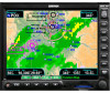
Detailed Operation IFR En Route Chart NOTE: The barometer setting is not displayed if the TAWS sensor is connected to the GMX 200 or if GPS altitude is used. Label The Label key turns the labels for each item on or off for easy decluttering. When Labels are turned off, only the symbol for waypoints along the flight plan will remain in view when the flight plan is enabled. Press the Next Page Menu Item key to display the next page of menu items. IFR Option Page 2 The second option page of the IFR Chart function lets you select options for the choices of Low Airways, High Airways, Airport Chart, and Load Approach Chart. The last option selection takes you back to the first page of options. Low Airways The Low Airways option allows you to control the display of Low Airways. You may select the display of the airway and label, airway alone, or no display of Low Airways by each subsequent press of the Menu Item key. High Airways The High Airways option allows you to control the display of High Airways. You may select the display of the airway and label, airway alone, or no display of Low Airways by each subsequent press of the Menu Item key. Airport Chart (Jepp ChartView) Airport surface charts provide a graphical presentation of the airport surface area (runways, taxiways, buildings, towers, and other objects), within the immediate airport vicinity. The Airport Chart item is not available with FliteCharts. IFR En Route Chart page with Menu Items (Page 2) From either the Custom Map or the IFR en route Map, airport surface charts will automatically be loaded and displayed as an overlay if the following conditions are met: • The airport surface chart is within the loaded database • The airport surface chart is geo-referenced by Jeppesen • Airport Chart menu layer is turned on • The aircraft position is within the coverage of the chart • A loaded approach chart is not being "flown" If an airport diagram is available in both the SafeTaxi and ChartView databases and the Airport Chart option is enabled, the ChartView airport chart will be displayed. The SafeTaxi airport diagram will be displayed if the Airport Chart option is disabled. 190-00607-02 Rev C 29
-
 1
1 -
2
-
3
-
4
-
5
-
6
-
7
-
8
-
9
-
10
-
11
-
12
-
13
-
14
-
15
-
16
-
17
-
18
-
19
-
20
-
21
-
22
-
23
-
24
-
25
-
26
-
27
-
28
-
29
-
30
-
31
-
32
-
33
-
34
-
35
-
 36
36 -
 37
37 -
 38
38 -
 39
39 -
 40
40 -
 41
41 -
 42
42 -
 43
43 -
 44
44 -
 45
45 -
 46
46 -
47
-
48
-
49
-
50
-
51
-
52
-
53
-
54
-
55
-
56
-
57
-
58
-
59
-
60
-
61
-
62
-
63
-
64
-
65
-
66
-
67
-
68
-
69
-
70
-
71
-
72
-
73
-
74
-
75
-
76
-
77
-
78
-
79
-
80
-
81
-
82
-
83
-
84
-
85
-
86
-
87
-
88
-
89
-
90
-
91
-
92
-
93
-
94
-
95
-
96
-
97
-
98
-
99
-
100
-
101
-
102
-
103
-
104
-
105
-
106
-
107
-
108
-
109
-
110
-
111
-
112
-
113
-
114
-
115
-
116
-
117
-
118
-
119
-
120
-
121
-
122
-
123
-
124
-
125
-
126
-
127
-
128
-
129
-
130
-
131
-
132
-
133
-
134
-
135
-
136
-
137
-
138
-
139
-
140
-
141
-
142
-
143
-
144
-
145
-
146
-
147
-
148
 |
 |
