Garmin GMX 200 Pilots Guide - Page 62
Terrain TER Function
 |
View all Garmin GMX 200 manuals
Add to My Manuals
Save this manual to your list of manuals |
Page 62 highlights
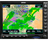
Detailed Operation Terrain Terrain (TER) Function The Terrain Function shows a map of the terrain in the area relative to your airplane's position and altitude. The GMX 200 has a standard internally based terrain function. The GMX 200 also supports an external TAWS sensor. When the external TAWS sensor is connected, it replaces the GMX 200's internal Terrain function. Terrain information can be supplied by one of two sources: • Internal GMX 200-Based Terrain • External TAWS-Based Terrain Review the Limitations section in the front of this guide for the limitations that apply to the terrain data. Internal GMX 200-Based Terrain The altitude information comes from an external altitude encoder or GPS altitude depending on your installation. For pressure altitude, displayed altimeter setting has to be adjusted, or baro-corrected, just like the one in your aircraft's instrument panel. The terrain screen has a 360-degree and a 120degree display. Both screens will show terrain relative to your position. Colors used for terrain display are shown below. Black Green Yellow Red Red Above your current altitude Current Altitude 100 feet below or at your current altitude Highest Terrain 1000 feet below your current altitude 2000 feet below your current altitude More than 2000 feet below your current altitude Terrain Elevation Color Coding Reference (Normal Terrain Model) NOTE: The Terrain function shows you the general terrain elevations relative to your altitude and are advisory in nature. Individual obstructions may be shown if available in the database. Terrain is displayed from database information and may therefore potentially contain some degree of error. Do not use this information for navigation. Obstructions Obstructions, such as towers and other man-made objects, are part of the GMX 200 updateable database. Obstructions over 250 feet high are shown on the maps with tower symbols. The symbol is color coded to signify the relative altitude of the tower to your aircraft's altitude and follows the same conventions as the color coding for terrain. Obstruction icons Terrain Page with GMX 200-Based Data Objects that are at your altitude are shown in red; objects that are near your altitude are shown in yellow; objects with towers that are significantly below your altitude colored green. Obstructions are shown on the 50 190-00607-02 Rev C
-
 1
1 -
2
-
3
-
4
-
5
-
6
-
7
-
8
-
9
-
10
-
11
-
12
-
13
-
14
-
15
-
16
-
17
-
18
-
19
-
20
-
21
-
22
-
23
-
24
-
25
-
26
-
27
-
28
-
29
-
30
-
31
-
32
-
33
-
34
-
35
-
36
-
37
-
38
-
39
-
40
-
41
-
42
-
43
-
44
-
45
-
46
-
47
-
48
-
49
-
50
-
51
-
52
-
53
-
54
-
55
-
56
-
 57
57 -
 58
58 -
 59
59 -
 60
60 -
 61
61 -
 62
62 -
 63
63 -
 64
64 -
 65
65 -
 66
66 -
 67
67 -
68
-
69
-
70
-
71
-
72
-
73
-
74
-
75
-
76
-
77
-
78
-
79
-
80
-
81
-
82
-
83
-
84
-
85
-
86
-
87
-
88
-
89
-
90
-
91
-
92
-
93
-
94
-
95
-
96
-
97
-
98
-
99
-
100
-
101
-
102
-
103
-
104
-
105
-
106
-
107
-
108
-
109
-
110
-
111
-
112
-
113
-
114
-
115
-
116
-
117
-
118
-
119
-
120
-
121
-
122
-
123
-
124
-
125
-
126
-
127
-
128
-
129
-
130
-
131
-
132
-
133
-
134
-
135
-
136
-
137
-
138
-
139
-
140
-
141
-
142
-
143
-
144
-
145
-
146
-
147
-
148
 |
 |
