Garmin GMX 200 Pilots Guide - Page 92
ChartView CHART Function Optional - jeppesen updates
 |
View all Garmin GMX 200 manuals
Add to My Manuals
Save this manual to your list of manuals |
Page 92 highlights
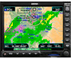
Detailed Operation ChartView - Chart ChartView (CHART) Function (Optional) The optional GMX 200 ChartView feature provides the capability to view Jeppesen Sanderson Inc. electronic charts. Two basic types of charts can be viewed: Approach charts and airport surface charts. Approach charts can be manually loaded and overlaid on the moving map during flight, while airport surface charts are automatically overlaid while on the ground. Both types of charts are also viewable from the ChartView Function in a manual fashion. Approach charts may also be loaded automatically when installed with a GNS 480-series GPS receiver. The electronic chart data is generated from the standard Jeppesen CD ROM product, which is distributed and updated by Jeppesen or from the Jeppesen web site. Charts are updated on a two-week schedule. The in-flight data resides on the pilot removable frontloading data card and is updated by the pilot using a home PC-based data loader. The GMX 200 ChartView feature does not currently represent a sole replacement for the paper chart within the cockpit. The presentation of the chart data is intended for supplemental use and to provide additional situational awareness. The pilot must still have access to the printed chart as required by FAA regulations. ChartView as viewed on the Custom Map Page Overview • Charts are viewed either as a dynamic overlay on the Custom/IFR Map, or as a static page through the dedicated ChartView Function ("Chart" on the function menu). • When viewed as a dynamic overlay on the Custom/IFR Map, the chart will be properly georeferenced with respect to the base map. Orientation (track up, north up, etc.), zoom scale, and aircraft position will all be properly presented relative to the chart data, using the standard map controls. • When viewed in the ChartView Function, more selection options are available for locating a specific chart among the charts in the database, and the chart is displayed similar to a standard chart manual (north up) with no position overlay. • A given approach chart must be "loaded" for map overlay usage by first selecting the airport of interest, then selecting the individual chart for that airport. Approach charts can be loaded from either the Custom/IFR Map or from the ChartView Function. 80 190-00607-02 Rev C
-
 1
1 -
2
-
3
-
4
-
5
-
6
-
7
-
8
-
9
-
10
-
11
-
12
-
13
-
14
-
15
-
16
-
17
-
18
-
19
-
20
-
21
-
22
-
23
-
24
-
25
-
26
-
27
-
28
-
29
-
30
-
31
-
32
-
33
-
34
-
35
-
36
-
37
-
38
-
39
-
40
-
41
-
42
-
43
-
44
-
45
-
46
-
47
-
48
-
49
-
50
-
51
-
52
-
53
-
54
-
55
-
56
-
57
-
58
-
59
-
60
-
61
-
62
-
63
-
64
-
65
-
66
-
67
-
68
-
69
-
70
-
71
-
72
-
73
-
74
-
75
-
76
-
77
-
78
-
79
-
80
-
81
-
82
-
83
-
84
-
85
-
86
-
 87
87 -
 88
88 -
 89
89 -
 90
90 -
 91
91 -
 92
92 -
 93
93 -
 94
94 -
 95
95 -
 96
96 -
 97
97 -
98
-
99
-
100
-
101
-
102
-
103
-
104
-
105
-
106
-
107
-
108
-
109
-
110
-
111
-
112
-
113
-
114
-
115
-
116
-
117
-
118
-
119
-
120
-
121
-
122
-
123
-
124
-
125
-
126
-
127
-
128
-
129
-
130
-
131
-
132
-
133
-
134
-
135
-
136
-
137
-
138
-
139
-
140
-
141
-
142
-
143
-
144
-
145
-
146
-
147
-
148
 |
 |
