Garmin GMX 200 Pilots Guide - Page 64
KGP-560 or KMH 820, or L3 Goodrich Landmark
 |
View all Garmin GMX 200 manuals
Add to My Manuals
Save this manual to your list of manuals |
Page 64 highlights
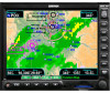
Detailed Operation Terrain When Baro +/Baro - are highlighted, you may then use the knob to adjust the barometric setting with the Rotary knob. TER Data Flag The TER flag will appear if no terrain data is available for the advisory coverage area. External TAWS-Based Terrain Display The external TAWS-based Terrain feature shows terrain as provided by an external TAWS sensor when connected to and configured to receive that data from either the KGP-560, Landmark 8000, or KMH 820. When displaying external TAWS-based terrain, the external sensor determines the color coding and graphical presentation of terrain in the proximity of the aircraft. See the Pilots Guide for the Honeywell KGP-560 or KMH 820, or L3 (Goodrich) Landmark for additional information on how to interpret this information. NOTE: When the GMX 200 is configured for an external Terrain Awareness and Warning System (TAWS), the "Baro" and "Alt" fields normally present on the Navigational Bar in the Custom Map function will not be displayed. Annunciation Description TAWS sensor is not available. Do not use TAWS information. Check the TAWS equipment and documentation for guidance. Your aircraft may be too low. Check the TAWS equipment for guidance. The TAWS equipment is in Test mode. Check the TAWS equipment for guidance. Your aircraft may be too low. Check the TAWS equipment for guidance. TAWS Pop-Up Modes The GMX 200 will detect TAWS based terrain alerts and will force a pop-up of the Terrain Function when required. Terrain based Pop-Ups have higher priority over traffic based pop-up functionality. The following table describes annunciations that may occur in the TAWS function. These annunciations are based on external information. If an annunciation appears, check the TAWS equipment and documentation for further information. Annunciation Description TAWS sensor is inoperative. Do not use TAWS information. TAWS sensor alerts are inhibited. Terrain Display of External TAWS-Based Data 52 190-00607-02 Rev C
-
 1
1 -
2
-
3
-
4
-
5
-
6
-
7
-
8
-
9
-
10
-
11
-
12
-
13
-
14
-
15
-
16
-
17
-
18
-
19
-
20
-
21
-
22
-
23
-
24
-
25
-
26
-
27
-
28
-
29
-
30
-
31
-
32
-
33
-
34
-
35
-
36
-
37
-
38
-
39
-
40
-
41
-
42
-
43
-
44
-
45
-
46
-
47
-
48
-
49
-
50
-
51
-
52
-
53
-
54
-
55
-
56
-
57
-
58
-
 59
59 -
 60
60 -
 61
61 -
 62
62 -
 63
63 -
 64
64 -
 65
65 -
 66
66 -
 67
67 -
 68
68 -
 69
69 -
70
-
71
-
72
-
73
-
74
-
75
-
76
-
77
-
78
-
79
-
80
-
81
-
82
-
83
-
84
-
85
-
86
-
87
-
88
-
89
-
90
-
91
-
92
-
93
-
94
-
95
-
96
-
97
-
98
-
99
-
100
-
101
-
102
-
103
-
104
-
105
-
106
-
107
-
108
-
109
-
110
-
111
-
112
-
113
-
114
-
115
-
116
-
117
-
118
-
119
-
120
-
121
-
122
-
123
-
124
-
125
-
126
-
127
-
128
-
129
-
130
-
131
-
132
-
133
-
134
-
135
-
136
-
137
-
138
-
139
-
140
-
141
-
142
-
143
-
144
-
145
-
146
-
147
-
148
 |
 |
