Garmin GMX 200 Pilots Guide - Page 30
Menu Item, North Up, Track Up, Track Up Arc, Track Up 360, Desired Track Up - error codes
 |
View all Garmin GMX 200 manuals
Add to My Manuals
Save this manual to your list of manuals |
Page 30 highlights
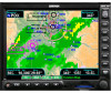
Detailed Operation Custom Map Custom Map Menu Option Page 1 The first option page of the Custom Map function lets you select options for the choices of Flight Plan, map orientation, Invert, Nav Data, and Load Chart. The last option selection takes you to the next page of options. For menu items with tri-state options, the active option is color coded in the item key label. When the option is clear, the icons and labels are not displayed. When the option has a cyan background, icons and labels are all shown. When the option box has a white background, only the icons are shown. North Up, Track Up, Track Up Arc, Track Up 360, and Desired Track Up. North Up sets magnetic north as the top of the screen. Track Up sets the current track of the aircraft as the top of the screen. Track Up Arc sets the current track of the aircraft and a 120° arc at the top of the screen. Track Up 360 sets the current track of the aircraft at the top of the screen and a 360° ring with the aircraft symbol position in the center. Desired Track Up sets the desired track to the next waypoint as the top of the screen. Press the Menu Item key next to this option to scroll through the options. Invert The Invert option changes the display of text and the background color. Depending on which layers are turned on, inverting the display may help readability for the current lighting conditions. For instance, when Terrain is shown, the Invert option switches between white and black text. When terrain is turned off, the Invert option switches between a white background with black text and a black background with white text. Custom Map page with Menu Items (page 1) Flight Plan The Flight Plan option controls the display of the Flight Plan course line. Pressing the Menu Item key next to the Flight Plan option toggles between showing or not showing the Flight Plan route line. If the flight plan provided by the navigator to the GMX 200 has an invalid cross track error, the ownship symbol will have a red "X" placed over it. Map Orientation This option controls the screen orientation in reference to the aircraft symbol. You may select from Nav Data The Nav Data option controls the display of navigation data. Subsequent presses of the Menu Item key for this option provides choices of no nav data, nav data in the corners (waypoint, bearing, zoom, and distance), or full nav data. The full nav data option includes the information in the four corners selection plus altitude, barometer setting, track, and ground speed. NOTE: Altitude and barometer setting information is not shown in TAWS installations. NOTE: When GPS altitude is configured, the barometer setting is not displayed. 18 190-00607-02 Rev C
-
 1
1 -
2
-
3
-
4
-
5
-
6
-
7
-
8
-
9
-
10
-
11
-
12
-
13
-
14
-
15
-
16
-
17
-
18
-
19
-
20
-
21
-
22
-
23
-
24
-
 25
25 -
 26
26 -
 27
27 -
 28
28 -
 29
29 -
 30
30 -
 31
31 -
 32
32 -
 33
33 -
 34
34 -
 35
35 -
36
-
37
-
38
-
39
-
40
-
41
-
42
-
43
-
44
-
45
-
46
-
47
-
48
-
49
-
50
-
51
-
52
-
53
-
54
-
55
-
56
-
57
-
58
-
59
-
60
-
61
-
62
-
63
-
64
-
65
-
66
-
67
-
68
-
69
-
70
-
71
-
72
-
73
-
74
-
75
-
76
-
77
-
78
-
79
-
80
-
81
-
82
-
83
-
84
-
85
-
86
-
87
-
88
-
89
-
90
-
91
-
92
-
93
-
94
-
95
-
96
-
97
-
98
-
99
-
100
-
101
-
102
-
103
-
104
-
105
-
106
-
107
-
108
-
109
-
110
-
111
-
112
-
113
-
114
-
115
-
116
-
117
-
118
-
119
-
120
-
121
-
122
-
123
-
124
-
125
-
126
-
127
-
128
-
129
-
130
-
131
-
132
-
133
-
134
-
135
-
136
-
137
-
138
-
139
-
140
-
141
-
142
-
143
-
144
-
145
-
146
-
147
-
148
 |
 |
