Garmin GMX 200 Pilots Guide - Page 60
Flight Plan FPL Function - replacement
 |
View all Garmin GMX 200 manuals
Add to My Manuals
Save this manual to your list of manuals |
Page 60 highlights
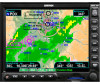
Detailed Operation Flight Plan Flight Plan (FPL) Function Use the Flight Plan function to view details about your flight plan route. Press the up/down arrow "smart" keys to step through the waypoints in your flight plan. Press the Info key to view information about the waypoint. The Flight Plan Function shows the Current Flight Plan that is active in the connected navigation source (i.e. GPS receiver). The Current To Waypoint box shows the current leg of the flight plan. The Current Flight Plan box shows all of the legs of your flight plan with the current leg indicated in magenta. Listed are each leg with the bearing and distance between the legs. The Current Nav Data box shows the aircraft current position in latitude and longitude, ground speed, and track. In the lower right corner information for the current waypoint is displayed in the Waypoint Info box. The Nearest Center frequency is shown just above the flight plan. The Flight Plan function does not have any options. If the flight plan provided by the navigator to the GMX 200 has an invalid cross track error, the ownship symbol will have a red "X" placed over it. METARs When METARs are available for an airport in the flight plan, the airport symbol is replaced with a METAR icon. When the Wx smart key is pressed, the METAR text will be displayed. Flight Plan Information with METAR information Runway diagrams of airports will be displayed in the same orientation as the Custom map (i.e., North Up, Track Up, or DTK Up). 1. Press the FPL function key to reach the Flight Plan function. 48 190-00607-02 Rev C
-
 1
1 -
2
-
3
-
4
-
5
-
6
-
7
-
8
-
9
-
10
-
11
-
12
-
13
-
14
-
15
-
16
-
17
-
18
-
19
-
20
-
21
-
22
-
23
-
24
-
25
-
26
-
27
-
28
-
29
-
30
-
31
-
32
-
33
-
34
-
35
-
36
-
37
-
38
-
39
-
40
-
41
-
42
-
43
-
44
-
45
-
46
-
47
-
48
-
49
-
50
-
51
-
52
-
53
-
54
-
 55
55 -
 56
56 -
 57
57 -
 58
58 -
 59
59 -
 60
60 -
 61
61 -
 62
62 -
 63
63 -
 64
64 -
 65
65 -
66
-
67
-
68
-
69
-
70
-
71
-
72
-
73
-
74
-
75
-
76
-
77
-
78
-
79
-
80
-
81
-
82
-
83
-
84
-
85
-
86
-
87
-
88
-
89
-
90
-
91
-
92
-
93
-
94
-
95
-
96
-
97
-
98
-
99
-
100
-
101
-
102
-
103
-
104
-
105
-
106
-
107
-
108
-
109
-
110
-
111
-
112
-
113
-
114
-
115
-
116
-
117
-
118
-
119
-
120
-
121
-
122
-
123
-
124
-
125
-
126
-
127
-
128
-
129
-
130
-
131
-
132
-
133
-
134
-
135
-
136
-
137
-
138
-
139
-
140
-
141
-
142
-
143
-
144
-
145
-
146
-
147
-
148
 |
 |
