Garmin GMX 200 Pilots Guide - Page 75
Animating Nexrad, Cloud Tops, or Surface Analy
 |
View all Garmin GMX 200 manuals
Add to My Manuals
Save this manual to your list of manuals |
Page 75 highlights
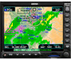
Product Times Detailed Operation GDL 69/69A - FIS Product times are shown on the lower portion of the display and cannot be hidden. The times for each of the enabled products (up to four at a time) are displayed. The time format shows day of month and then hours and minutes in Zulu time. For instance, METAR: 24 2036Z would mean that product time reported was on the 24th of the current month at 20:36 Zulu time. The following product times are shown: Nexrad for NEXRAD radar, Coverage for active NEXRAD radar coverage areas, METAR, Echo Tops, Cloud Tops, Lightning, and Winds Aloft. Times are Zulu times when the data was assembled on the ground, not the time the data was received or displayed by the FIS sensor. The Winds Aloft product time includes the selected Winds Aloft Altitude. Product times are shown in white when they are initially shown and change to blue and then yellow as they pass certain age thresholds. A product time aging table is shown below. For a GMX 200 that does not have time available from a GPS receiver, age is based on the time the data was received from the GDL 69/69A sensor. In this case, the age of the data may be older than what is shown by the color coding. Animating Nexrad, Cloud Tops, or Surface Analysis products will disable the depiction of other enabled products. The product time for the other enabled products will be displayed as "N/A" while animation is active. FIS Product Times Goes Blue After Goes Yellow After (Minutes) (Minutes) NEXRAD 8 13 Graphical METAR 15 75 Lightning 8 23 Cell Movement 4.25 5.5 Radar Coverage 8 13 Echo Tops 10.5 18 Winds Aloft 15 75 AIRMET 15 51 SIGMET 15 51 Cyclone 15 51 County Warnings 8 23 Freezing Level 15 75 City Forecasts 15 51 Surface Analysis 15 195 Cloud Tops 10.5 18 Forecast Weather forecast information is provided for an available City, SIGMETs, AIRMETs, Freezing Levels, County warnings, and Cyclones. While using this feature you can also customize the display of information showing map labels, flight plan line, and legend. 190-00607-02 Rev C 63
-
 1
1 -
2
-
3
-
4
-
5
-
6
-
7
-
8
-
9
-
10
-
11
-
12
-
13
-
14
-
15
-
16
-
17
-
18
-
19
-
20
-
21
-
22
-
23
-
24
-
25
-
26
-
27
-
28
-
29
-
30
-
31
-
32
-
33
-
34
-
35
-
36
-
37
-
38
-
39
-
40
-
41
-
42
-
43
-
44
-
45
-
46
-
47
-
48
-
49
-
50
-
51
-
52
-
53
-
54
-
55
-
56
-
57
-
58
-
59
-
60
-
61
-
62
-
63
-
64
-
65
-
66
-
67
-
68
-
69
-
 70
70 -
 71
71 -
 72
72 -
 73
73 -
 74
74 -
 75
75 -
 76
76 -
 77
77 -
 78
78 -
 79
79 -
 80
80 -
81
-
82
-
83
-
84
-
85
-
86
-
87
-
88
-
89
-
90
-
91
-
92
-
93
-
94
-
95
-
96
-
97
-
98
-
99
-
100
-
101
-
102
-
103
-
104
-
105
-
106
-
107
-
108
-
109
-
110
-
111
-
112
-
113
-
114
-
115
-
116
-
117
-
118
-
119
-
120
-
121
-
122
-
123
-
124
-
125
-
126
-
127
-
128
-
129
-
130
-
131
-
132
-
133
-
134
-
135
-
136
-
137
-
138
-
139
-
140
-
141
-
142
-
143
-
144
-
145
-
146
-
147
-
148
 |
 |
