Garmin GMX 200 Pilots Guide - Page 28
Custom Map MAP - reviews
 |
View all Garmin GMX 200 manuals
Add to My Manuals
Save this manual to your list of manuals |
Page 28 highlights
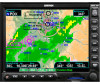
Detailed Operation Custom Map Custom Map (MAP) The Custom Map function provides a graphic display of map features in relation to the aircraft location to help improve situational awareness. Review the Limitations section in the front of this guide that apply to using data displayed on the moving map. The custom map function is unique in allowing you to selectively "overlay" all available types of information onto a single display. Press the MENU/ENT key to display a list of options on the right side of the screen. Press the Menu Item key next to the displayed option. Repeated presses of the Menu Item key will scroll through the available selections for each option. Turning on too many layers may clutter the display. The "smart" keys at the bottom of the display over the function keys control the map scale by zooming in or out, moving the map view around with the Pan feature, and viewing Info about the current destination waypoint. Initial Zoom Level The initial zoom level that is used on start-up is determined by a setting made in the System Function. Map Scale The In and Out function keys control the map scale by zooming in and out. You can zoom in to 0.25 NM and zoom out to 1250 NM. The scale distance is measured from the location of your aircraft symbol to the top of the screen. The Map Scale is shown in the lower left corner of the screen. The map orientation appears above the map scale. Map Orientation and Zoom Level (Map Scale) Auto Zoom Auto Zoom is activated by adjusting the zoom level to the far extremes of the zoom range. When activated, the indicated zoom level will change from a number to the text "A," followed by the zoom scale. While in the Auto Zoom mode, the screen will automatically adjust the current zoom level to maintain the current "TO" waypoint on the screen. When approaching the waypoint, the zoom level will not drop below 2 NM. When the waypoint is reached and the next waypoint in the flight plan becomes active, the zoom level will automatically adjust to bring that waypoint on the map. When installed with a GNS 480-series GPS receiver, the GMX 200 zoom level can be controlled by the GNS 480. This feature must be enabled in the System function with the "Slave Zoom to GPS Zoom" setting enabled. To exit the autozoom mode, simply increase or decrease the current zoom level to re-enter the manual adjust mode. Map Scale and Map Orientation Barometric Pressure Track Angle Distance from Present Position to Next Waypoint Pressure Altitude Above Mean Sea Level Ground Speed 16 190-00607-02 Rev C
-
 1
1 -
2
-
3
-
4
-
5
-
6
-
7
-
8
-
9
-
10
-
11
-
12
-
13
-
14
-
15
-
16
-
17
-
18
-
19
-
20
-
21
-
22
-
 23
23 -
 24
24 -
 25
25 -
 26
26 -
 27
27 -
 28
28 -
 29
29 -
 30
30 -
 31
31 -
 32
32 -
 33
33 -
34
-
35
-
36
-
37
-
38
-
39
-
40
-
41
-
42
-
43
-
44
-
45
-
46
-
47
-
48
-
49
-
50
-
51
-
52
-
53
-
54
-
55
-
56
-
57
-
58
-
59
-
60
-
61
-
62
-
63
-
64
-
65
-
66
-
67
-
68
-
69
-
70
-
71
-
72
-
73
-
74
-
75
-
76
-
77
-
78
-
79
-
80
-
81
-
82
-
83
-
84
-
85
-
86
-
87
-
88
-
89
-
90
-
91
-
92
-
93
-
94
-
95
-
96
-
97
-
98
-
99
-
100
-
101
-
102
-
103
-
104
-
105
-
106
-
107
-
108
-
109
-
110
-
111
-
112
-
113
-
114
-
115
-
116
-
117
-
118
-
119
-
120
-
121
-
122
-
123
-
124
-
125
-
126
-
127
-
128
-
129
-
130
-
131
-
132
-
133
-
134
-
135
-
136
-
137
-
138
-
139
-
140
-
141
-
142
-
143
-
144
-
145
-
146
-
147
-
148
 |
 |
