Garmin GMX 200 Pilots Guide - Page 38
Check your Approved Flight Manual Supplement - terrain update
 |
View all Garmin GMX 200 manuals
Add to My Manuals
Save this manual to your list of manuals |
Page 38 highlights
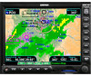
Detailed Operation Custom Map Obstructions Obstructions, such as towers and other man-made objects, are part of the GMX 200 updateable database. Obstructions over 250 feet high are shown on the maps with tower symbols. The symbol is color coded to signify the relative altitude of the tower to your aircraft's altitude and follows the same conventions as the color coding for terrain. Obstruction icons Objects that are within 100 feet of your altitude are shown in red; objects that are within 1000 feet of your altitude are shown in yellow; objects with towers that are more than 1000 feet below your altitude are colored green. When altitude data is lost, objects are shown in cyan. Obstructions are shown on the Custom Map and in the Terrain function. For information on the Internal GMX 200-Based Terrain color coding, see the Terrain Function description in the Detailed operation section. Review the Limitations section in the front of this guide. Current coverage for obstructions is North America only and are drawn only when the zoom scale is 50 NM or less. Traffic The Traffic option turns the display of traffic information on or off. ADS-B Traffic information includes the location and identifier of a reporting aircraft, its direction of travel, elevation, and the estimated path for the selected time interval. See the section on the Traffic mode for more details on how traffic information is used. A small thumbnail presentation of traffic is presented in the upper left corner of the display. Traffic targets can also be overlaid on the Custom Map page. The Traffic function is an optional installation. Check your Approved Flight Manual Supplement to verify if this feature is available. Review the Limitations section in the front of this guide. Strikes The Strikes menu option controls the display of lightning strike information if the GMX 200 receives strike data from an external source, such as the WX500. Each reported lightning strike is shown as an "x" on the display. Strikes are not shown if the zoom scale is below 20 NM, or above 400 NM. Lightning strike icon ("x") Custom Map page with Obstructions, Traffic, Lightning Strikes, and Menu Items (Page 4) Press the Main Menu key to return to the first page of menu items. 26 190-00607-02 Rev C
-
 1
1 -
2
-
3
-
4
-
5
-
6
-
7
-
8
-
9
-
10
-
11
-
12
-
13
-
14
-
15
-
16
-
17
-
18
-
19
-
20
-
21
-
22
-
23
-
24
-
25
-
26
-
27
-
28
-
29
-
30
-
31
-
32
-
 33
33 -
 34
34 -
 35
35 -
 36
36 -
 37
37 -
 38
38 -
 39
39 -
 40
40 -
 41
41 -
 42
42 -
 43
43 -
44
-
45
-
46
-
47
-
48
-
49
-
50
-
51
-
52
-
53
-
54
-
55
-
56
-
57
-
58
-
59
-
60
-
61
-
62
-
63
-
64
-
65
-
66
-
67
-
68
-
69
-
70
-
71
-
72
-
73
-
74
-
75
-
76
-
77
-
78
-
79
-
80
-
81
-
82
-
83
-
84
-
85
-
86
-
87
-
88
-
89
-
90
-
91
-
92
-
93
-
94
-
95
-
96
-
97
-
98
-
99
-
100
-
101
-
102
-
103
-
104
-
105
-
106
-
107
-
108
-
109
-
110
-
111
-
112
-
113
-
114
-
115
-
116
-
117
-
118
-
119
-
120
-
121
-
122
-
123
-
124
-
125
-
126
-
127
-
128
-
129
-
130
-
131
-
132
-
133
-
134
-
135
-
136
-
137
-
138
-
139
-
140
-
141
-
142
-
143
-
144
-
145
-
146
-
147
-
148
 |
 |
