Garmin GPS 12XL Owner's Manual (Software Version 2.00-3.62) - Page 31
Route Definition
 |
UPC - 753759007034
View all Garmin GPS 12XL manuals
Add to My Manuals
Save this manual to your list of manuals |
Page 31 highlights
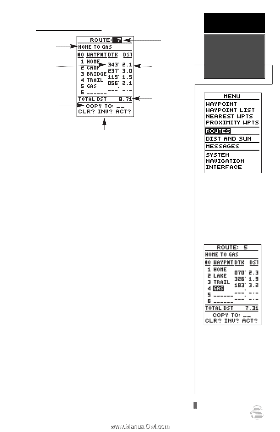
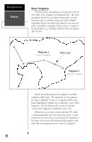
Route Definition Page Comment Field Desired Track of Leg Copy Field Route Number Leg Distance REFERENCE Route Definition Page Total Distance Function Prompts The last form of navigating to a destination with the GPS 12XL is by creating a user-defined route. The GPS 12XL lets you create and store up to 20 routes of 30 waypoints each. The route navigation feature lets you plan and navigate a course from one place to another using a set of pre-defined waypoints. Routes are often used when it's not practical, safe, or possible to navigate a direct course to a particular destination (e.g., through a body of water or impassable terrain). The bottom of the route definition page features several 'function' fields which let you copy, clear, invert, or activate the displayed route. Routes 1-19 are used as storage routes, with route 0 always serving as the active route you are navigating. If you want to save a route that's currently in route 0, be sure to copy it to another open route, as it will be overwritten by the next route activation. Routes can be copied, cleared, inverted, and activated through the route definition page. To select the route definition page: 1. Highlight 'ROUTES' from the Menu Page, and press E. The 'route number' field is displayed at the top of the page, with a 16-character 'user comment' field to the right. If no user comment is entered, the field displays the first and last waypoint in the route. The waypoint list on the left side of the page accepts up to 30 waypoints for each route, with fields for desired track and distance between legs. The total route distance is indicated below the waypoint list. Routes enable you to store and use groups of frequently used waypoints together. Enter each waypoint in the order you would like to navigate them. If you enter a waypoint not stored in memory, you'll need to define the position on the waypoint definition page. 27
-
 1
1 -
2
-
3
-
4
-
5
-
6
-
7
-
8
-
9
-
10
-
11
-
12
-
13
-
14
-
15
-
16
-
17
-
18
-
19
-
20
-
21
-
22
-
23
-
24
-
25
-
 26
26 -
 27
27 -
 28
28 -
 29
29 -
 30
30 -
 31
31 -
 32
32 -
 33
33 -
 34
34 -
 35
35 -
 36
36 -
37
-
38
-
39
-
40
-
41
-
42
-
43
-
44
-
45
-
46
-
47
-
48
-
49
-
50
-
51
-
52
-
53
-
54
-
55
-
56
-
57
-
58
-
59
-
60
-
61
-
62
-
63
-
64
 |
 |