Garmin GPS 12XL Owner's Manual (Software Version 2.00-3.62) - Page 57
Appendix C
 |
UPC - 753759007034
View all Garmin GPS 12XL manuals
Add to My Manuals
Save this manual to your list of manuals |
Page 57 highlights
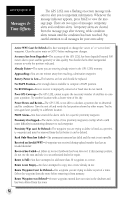
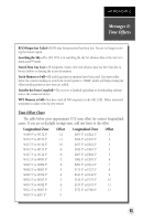
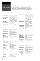
APPENDIX C Messages & Time Offsets RTCM Input has Failed-DGPS data being received has been lost. You are no longer receiving the beacon signal. Searching the Sky-The GPS 12XL is in searching the sky for almanac data or the unit is in AutoLocateTM mode. Stored Data was Lost-All waypoints, routes, time and almanac data has been lost due to battery failure or clearing the receiver's memory. Track Memory is Full-All track log points in memory have been used. You must either delete the current tracklog or switch the record option to 'WRAP' which will begin erasing the oldest tracklog points as new ones are added. Transfer has been Completd-The receiver is finished uploading or downloading information to the connected device. WPT Memory is Full-You have used all 500 waypoints in the GPS 12XL. Delete unwanted waypoints to make room for new entries. Time Offset Chart The table below gives approximate UTC time offset for various longitudinal zones. If you are in daylight savings time, add one hour to the offset. Longitudinal Zone Offset Longitudinal Zone Offset W180.0º to W172.5º -12 E007.5º to E022.5º 1 W172.5º to W157.5º -11 E022.5º to E037.5º 2 W157.5º to W142.5º -10 E037.5º to E052.5º 3 W142.5º to W127.5º -9 E052.5º to E067.5º 4 W127.5º to W112.5º -8 E067.5º to E082.5º 5 W112.5º to W097.5º -7 W097.5º to W082.5º -6 W082.5º to W067.5º -5 W067.5º to W052.5º -4 W052.5º to W037.5º -3 E082.5º to E097.5º 6 E097.5º to E112.5º 7 E112.5º to E127.5º 8 E127.5º to E142.5º 9 E142.5º to E157.5º 10 W037.5º to W022.5º -2 W022.5º to W007.5º -1 W007.5º to E007.5º 0 E157.5º to E172.5º 11 E172.5º to E180.0º 12 53
-
 1
1 -
2
-
3
-
4
-
5
-
6
-
7
-
8
-
9
-
10
-
11
-
12
-
13
-
14
-
15
-
16
-
17
-
18
-
19
-
20
-
21
-
22
-
23
-
24
-
25
-
26
-
27
-
28
-
29
-
30
-
31
-
32
-
33
-
34
-
35
-
36
-
37
-
38
-
39
-
40
-
41
-
42
-
43
-
44
-
45
-
46
-
47
-
48
-
49
-
50
-
51
-
 52
52 -
 53
53 -
 54
54 -
 55
55 -
 56
56 -
 57
57 -
 58
58 -
 59
59 -
 60
60 -
 61
61 -
 62
62 -
63
-
64
 |
 |