Garmin GPS 12XL Owner's Manual (Software Version 2.00-3.62) - Page 61
Power and Data Cables ..51
 |
UPC - 753759007034
View all Garmin GPS 12XL manuals
Add to My Manuals
Save this manual to your list of manuals |
Page 61 highlights
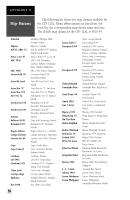
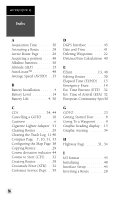
APPENDIX E Index M Mag. Heading Reference . .44 Man Overboard Function .23 Map Cursor 37 Map Datums 43, 54 Map Orientation 38 Map Page 7, 9, 35 Map Setup 38 Marking a Position 8 Maximum Speed 16 Maximum Speed (MXSPD) 15 Menu Page 7, 40 Messages 52 N NMEA Formats 51 Navigating Routes . . . . . .28 Navigation Page . . . . . .7, 31 Navigation Setup 43 Nearest Waypoints . . . . . .18 O On-Route GOTOs . . . . . .30 Operating modes 41 P PC Kit i, 51 Panning 36 Position Accuracy . . . . . .50 Position Averaging . . . . . .17 Position Formats 43 Position Page 6, 15 Power and Data Cables . . .51 Pre-defined waypoints . . .27 Primary Pages 6 Proximity Waypoints . . . .19 R Receiver Status 13 Reference Waypoints . . . .20 Renaming Waypoints . . . .22 Repairs 50 Routes Clearing 29 Copying 29 Creating 28 Editing 30 Inverting 28 Navigating Routes . . . . .28 On-Route GOTO's . . . .30 Route Definition Page . .27 Route Navigation . . . . .26 User-defined route . . . .27 S Satellite Page 6, 12 Scanning Waypoints . . . . .22 Screen Backlighting . .14, 42 Screen Contrast . . . . .11, 42 Signal Strength Bars . . . . .12 Simulator 47 Sky View 12 Specifications 50 System Setup 41 57
-
 1
1 -
2
-
3
-
4
-
5
-
6
-
7
-
8
-
9
-
10
-
11
-
12
-
13
-
14
-
15
-
16
-
17
-
18
-
19
-
20
-
21
-
22
-
23
-
24
-
25
-
26
-
27
-
28
-
29
-
30
-
31
-
32
-
33
-
34
-
35
-
36
-
37
-
38
-
39
-
40
-
41
-
42
-
43
-
44
-
45
-
46
-
47
-
48
-
49
-
50
-
51
-
52
-
53
-
54
-
55
-
 56
56 -
 57
57 -
 58
58 -
 59
59 -
 60
60 -
 61
61 -
 62
62 -
 63
63 -
 64
64
 |
 |