Garmin GPS 12XL Owner's Manual (Software Version 2.00-3.62) - Page 48
Datums, CDI, Settings, &, Measurement
 |
UPC - 753759007034
View all Garmin GPS 12XL manuals
Add to My Manuals
Save this manual to your list of manuals |
Page 48 highlights
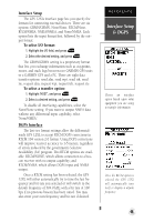
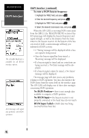
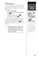
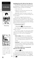
REFERENCE Datums, CDI Settings, & Measurement The user datum feature allows you to define the earth model used to calculate position coordinates. WARNING: Incorrect entries may result in substantial position errors. To enter a user-defined magnetic variation, select the 'User Mag' option and enter the desired direction and value. 44 Map Datums (continued) To define a user datum: 1. Highlight the 'MAP DATUM' field, and press E. 2. Scroll through the map datum options until 'User' appears, and press E. 3. Enter values for 'DX', 'DY', 'DZ', 'DA', and 'DF' using the rocker keypad, and press E. 4. Highlight 'SAVE?', and press E. The setup menu will reappear. CDI Scale Settings The course deviation indicator (CDI) field lets you select the +/- range of the CDI bar scale on the Highway Page. Three scales are available: +/- 0.25 (default), 1.25, and 5.0 miles or kilometers. Note: This CDI value represents the full deflection of scale to either side. To enter a CDI scale setting: 1. Highlight the 'CDI SCALE' field, and press E. 2. Select the desired setting, and press E. Units of Measure The GPS 12XL lets you select statute (default), nau- tical, or metric units of measure for all "speed" and "distance" fields. To change the unit of measure: 1. Highlight the 'UNITS' field, and press E. 2. Select the desired unit of measure, and press E. Magnetic Heading Reference The GPS 12XL's heading information can be dis- played referencing magnetic north (automatic or userdefined), true north, or calculated grid headings. The default setting is automatic magnetic north, which is suitable for most applications. To select a heading reference: 1. Highlight the 'HEADING' field, and press E. 2. Select the desired heading preference, and press E. To enter a user-defined magnetic heading: . 1. Select 'User Mag' and press E. 2. Enter the degrees and direction of magnetic variation, and press E.
-
 1
1 -
2
-
3
-
4
-
5
-
6
-
7
-
8
-
9
-
10
-
11
-
12
-
13
-
14
-
15
-
16
-
17
-
18
-
19
-
20
-
21
-
22
-
23
-
24
-
25
-
26
-
27
-
28
-
29
-
30
-
31
-
32
-
33
-
34
-
35
-
36
-
37
-
38
-
39
-
40
-
41
-
42
-
 43
43 -
 44
44 -
 45
45 -
 46
46 -
 47
47 -
 48
48 -
 49
49 -
 50
50 -
 51
51 -
 52
52 -
 53
53 -
54
-
55
-
56
-
57
-
58
-
59
-
60
-
61
-
62
-
63
-
64
 |
 |
