Harman Kardon TRAFFIC PRO Owners Manual - Page 10
Using Navigation
 |
View all Harman Kardon TRAFFIC PRO manuals
Add to My Manuals
Save this manual to your list of manuals |
Page 10 highlights
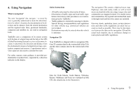
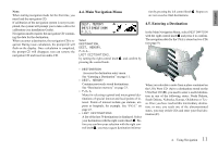
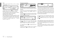
US english 4. Using Navigation What is navigation? The term "navigation" (lat. navigare = to travel by sea) is generally understood to mean the determination of a vehicle's location, the determination of its direction and its distance from the desired destination and the required route. Stars, prominent landmarks, compasses and satellites etc. are used as navigation tools. TrafficPro uses a comparison of its sensor system with the data of a digital map and the help of the GPS (Global Positioning System) receiver to determine location. It determines the direction and distance from the destination by means of a digital street map, a navigation computer and sensors. A speedometer and reverse signal are also used to calculate the route. Safety Instructions - All traffic rules must be observed at all times. - Observation of traffic signs and local traffic regu- lations must always take precedence over instructions given by TrafficPro. - Traffic guidance is restricted to passenger vehicles. Special driving recommendations and regulations for other vehicles (e.g. commercial vehicles) are not included. - Destinations may only be entered when the vehicle is stationary. Navigation CD Your TrafficPro is shipped with two navigation CDs. One CD contains data for the western half of the USA and the other contains data for the eastern half of the USA. The navigation CDs contain a digitized street map. Highways, state and county roads, as well as local streets are detailed in this street map. Larger cities and communities are mapped in detail. For smaller towns and communities, the regional and unclassified roads or through-roads and the town centers are included. One-way streets, pedestrian zones, no-turn intersections and other traffic regulations are taken into account as much as possible. There may be discrepancies between the data on the navigation CD and the actual local situation, due to continuous changes to road systems and traffic regulations. For safety reasons, route guidance is provided predominantly in spoken form , supported by a direction indicator on the display. Data for North Dakota, South Dakota, Nebraska, Kansas, Oklahoma, and Texas are contained on both CDs (the striped area on the illustration). 4. Using Navigation 9
-
 1
1 -
2
-
3
-
4
-
 5
5 -
 6
6 -
 7
7 -
 8
8 -
 9
9 -
 10
10 -
 11
11 -
 12
12 -
 13
13 -
 14
14 -
 15
15 -
16
-
17
-
18
-
19
-
20
-
21
-
22
-
23
-
24
-
25
-
26
-
27
-
28
-
29
-
30
-
31
-
32
-
33
-
34
-
35
-
36
-
37
-
38
-
39
-
40
-
41
-
42
-
43
-
44
-
45
-
46
-
47
-
48
 |
 |
