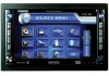
Jensen VM9022HDN Operation Manual - Page 43
Key Features, Smart2Go Navigation / Tele Atlas Map Data, About GPS and GNSS
 |
UPC - 043258304322
View all Jensen VM9022HDN manuals
Add to My Manuals
Save this manual to your list of manuals |
Page 43 highlights
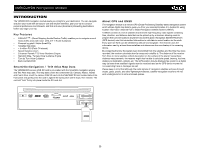
VM9022HDN Navigation Module INTRODUCTION The VM9022HDN navigation module leads you straight to your destination. You can navigate and plan your route with an easy-to-use and intuitive interface, plan your trip to suit your personal preferences and interests, and find and save (bookmark) interesting destinations before you begin your trip. Key Features • S.M.A.R.T.TM - (Smart Mapping Avoids Routine Traffic) enables you to navigate around heavy traffic areas with ease. (S.M.A.R.T. Route Guidance) • Powered by gate5 / Nokia Smart2Go • Teleatlas Map Data • > 4 million POI (Point Of Interest) • Speed Sensitive Zoom • Enhanced Female TTS Voice Guidance Engine • Standard Male / Female Voice Guidance Engine • Turn by Turn Voice Guidance • Back-Up Data DVD Smart2Go Navigation / Tele Atlas Map Data The VM9022HDN Jensen 2GB SD card is pre-loaded with the Smart2Go navigation engine and Tele Atlas map data. The map data covers the continental US, Canada, Alaska, Hawaii and Puerto Rico. Insert the Jensen 2GB SD card into the NAV/MAP SD slot located behind the front panel and gently press the card in against the spring latch until it stops, then release. The card will "lock" firmly into place inside the SD card slot. About GPS and GNSS The navigation module is a vehicle GPS (Global Positioning Satellite)-based navigation system which utilizes digital map data to guide you from your selected location A to location B, using location information obtained from a Global Navigation Satellite System (GNSS). A GNSS consists of a set of satellites that transmit high-frequency radio signals containing time, direction, and distance data that can be picked up by a receiver, allowing users to pinpoint their precise locations anywhere around the globe. Navigation Satellite Receivers (GPS devices) use this transmitted information to calculate an exact location on the earth. Every point on Earth can be identified by latitude and longitude. The receiver uses the information sent by at least three satellites and determines the coordinates of the receiving device. By comparing the time the signals were transmitted from the satellites and the time they were recorded, the receiver calculates how far away each satellite is. The distance of the receiver from three or more satellites reflects its position on the surface of the planet. Using these distance measurements, the receiver might also be able to calculate speed, bearing, trip time, distance to destination, altitude, etc. The GPS position may be displayed as a point on a digital map (at least three satellites' signals must be received) and as the GPS device moves the corresponding trace is displayed as well. Please keep in mind that although the radio signals of navigation satellites will pass through clouds, glass, plastic, and other lightweight materials, satellite-navigation receivers will not work underground or in some enclosed spaces. EJECT UP UP CARDNAV/MAP READER 39
-
 1
1 -
2
-
3
-
4
-
5
-
6
-
7
-
8
-
9
-
10
-
11
-
12
-
13
-
14
-
15
-
16
-
17
-
18
-
19
-
20
-
21
-
22
-
23
-
24
-
25
-
26
-
27
-
28
-
29
-
30
-
31
-
32
-
33
-
34
-
35
-
36
-
37
-
 38
38 -
 39
39 -
 40
40 -
 41
41 -
 42
42 -
 43
43 -
 44
44 -
 45
45 -
 46
46 -
 47
47 -
 48
48 -
49
-
50
-
51
-
52
-
53
-
54
-
55
-
56
-
57
-
58
-
59
-
60
-
61
-
62
-
63
-
64
 |
 |
