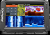
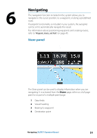
Lowrance Elite-12 Ti Operator Manual EN - Page 50
Trails, Creating new Trails, Trails settings
 |
View all Lowrance Elite-12 Ti manuals
Add to My Manuals
Save this manual to your list of manuals |
Page 50 highlights
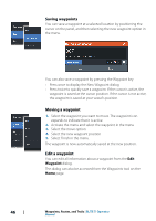
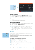
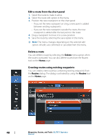
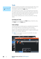
Trails Trails are a graphical presentation of the historical path of the vessel, allowing you to retrace where you have travelled. Trails can be converted to routes from the Edit dialog. From the factory, the system is set to automatically track and draw the vessel's movement on the chart panel. The system continues to record the Trails until the length reaches the maximum points, and then automatically begins overwriting the oldest points. The automatic tracking function can be turned off from the Trails dialog. Creating new Trails You can start a new trail from the Trails dialog, activated by using the Trails tool on the Home page. Trails settings Trails are made up of a series of points connected by line segments whose length depends on the frequency of the recording. You can select to position trail points based on time settings, distance, or by letting the system position a waypoint automatically when a course change is registered. Ú Note: The Trails option must also be turned ON in the chart settings to be visible. 50 Waypoints, Routes, and Trails | ELITE Ti Operator Manual
-
 1
1 -
2
-
3
-
4
-
5
-
6
-
7
-
8
-
9
-
10
-
11
-
12
-
13
-
14
-
15
-
16
-
17
-
18
-
19
-
20
-
21
-
22
-
23
-
24
-
25
-
26
-
27
-
28
-
29
-
30
-
31
-
32
-
33
-
34
-
35
-
36
-
37
-
38
-
39
-
40
-
41
-
42
-
43
-
44
-
 45
45 -
 46
46 -
 47
47 -
 48
48 -
 49
49 -
 50
50 -
 51
51 -
 52
52 -
 53
53 -
 54
54 -
 55
55 -
56
-
57
-
58
-
59
-
60
-
61
-
62
-
63
-
64
-
65
-
66
-
67
-
68
-
69
-
70
-
71
-
72
-
73
-
74
-
75
-
76
-
77
-
78
-
79
-
80
-
81
-
82
-
83
-
84
-
85
-
86
-
87
-
88
-
89
-
90
-
91
-
92
-
93
-
94
-
95
-
96
-
97
-
98
-
99
-
100
-
101
-
102
-
103
-
104
-
105
-
106
-
107
-
108
-
109
-
110
-
111
-
112
-
113
-
114
-
115
-
116
-
117
-
118
-
119
-
120
-
121
-
122
-
123
-
124
-
125
-
126
-
127
-
128
-
129
-
130
 |
 |
