Garmin aera 660 aera 660 Pilot s Guide - Page 104
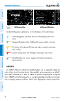
AIRMETS, The METAR flag color is determined by the information in the METAR text.
 |
View all Garmin aera 660 manuals
Add to My Manuals
Save this manual to your list of manuals |
Page 104 highlights
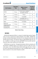
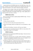
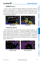
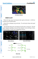
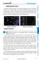
Hazard Avoidance Overview Navigation Additional Features Hazard Avoidance Flight Planning Map Feature Button METAR Data (Map) Additional METAR Data The METAR flag color is determined by the information in the METAR text. VFR (ceiling greater than 3000 feet AGL and visibility greater than 5 miles) Marginal VFR (ceiling 1000-3000 feet AGL and/or visibility 3-5 miles) IFR (ceiling 500 to below 1000 feet AGL and/or visibility 1 mile to less than 3 miles) Low IFR (ceiling below 500 feet AGL or visibility less than 1 mile) METAR text does not contain adequate information to determine flight conditions AIRMETS An AIRMET (AIRmen's METeorological Information) can be especially helpful for pilots of light aircraft that have limited flight capability or instrumentation. An AIRMET must affect or be forecast to affect an area of at least 3,000 square miles at any one time. AIRMETs are routinely issued for six-hour periods and are amended as necessary due to changing weather conditions. AIRMETs are displayed as colored, dashed lines. 88 Garmin aera 660 Pilot's Guide 190-02017-20 Rev. A Appendices Index
-
 1
1 -
2
-
3
-
4
-
5
-
6
-
7
-
8
-
9
-
10
-
11
-
12
-
13
-
14
-
15
-
16
-
17
-
18
-
19
-
20
-
21
-
22
-
23
-
24
-
25
-
26
-
27
-
28
-
29
-
30
-
31
-
32
-
33
-
34
-
35
-
36
-
37
-
38
-
39
-
40
-
41
-
42
-
43
-
44
-
45
-
46
-
47
-
48
-
49
-
50
-
51
-
52
-
53
-
54
-
55
-
56
-
57
-
58
-
59
-
60
-
61
-
62
-
63
-
64
-
65
-
66
-
67
-
68
-
69
-
70
-
71
-
72
-
73
-
74
-
75
-
76
-
77
-
78
-
79
-
80
-
81
-
82
-
83
-
84
-
85
-
86
-
87
-
88
-
89
-
90
-
91
-
92
-
93
-
94
-
95
-
96
-
97
-
98
-
 99
99 -
 100
100 -
 101
101 -
 102
102 -
 103
103 -
 104
104 -
 105
105 -
 106
106 -
 107
107 -
 108
108 -
 109
109 -
110
-
111
-
112
-
113
-
114
-
115
-
116
-
117
-
118
-
119
-
120
-
121
-
122
-
123
-
124
-
125
-
126
-
127
-
128
-
129
-
130
-
131
-
132
-
133
-
134
-
135
-
136
-
137
-
138
-
139
-
140
-
141
-
142
-
143
-
144
-
145
-
146
-
147
-
148
-
149
-
150
-
151
-
152
-
153
-
154
-
155
-
156
-
157
-
158
-
159
-
160
-
161
-
162
-
163
-
164
-
165
-
166
-
167
-
168
-
169
-
170
-
171
-
172
-
173
-
174
-
175
-
176
-
177
-
178
-
179
-
180
-
181
-
182
-
183
-
184
-
185
-
186
-
187
-
188
-
189
-
190
-
191
-
192
-
193
-
194
-
195
-
196
-
197
-
198
-
199
-
200
-
201
-
202
-
203
-
204
 |
 |
