Garmin aera 660 aera 660 Pilot s Guide - Page 139
Appendix B: Abnormal Operation, Loss of GNSS Position, Hazard Display with Loss of GNSS Position
 |
View all Garmin aera 660 manuals
Add to My Manuals
Save this manual to your list of manuals |
Page 139 highlights
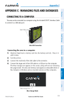
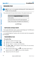
Overview Appendix B APPENDIX B: ABNORMAL OPERATION LOSS OF GNSS POSITION When the aera loses the GNSS signal for any reason, the following will occur: • A blinking red question mark will appear over the airplane icon on the map. • The 'Lost Satellite Reception' message will display. • Any GNSS dependent data fields will not be available. Navigation Flight Planning Hazard Avoidance Additional Features GNSS Signal Lost HAZARD DISPLAY WITH LOSS OF GNSS POSITION If the Terrain function doesn't have at least a 3D fix (i.e. altitude unknown), a Red X will be displayed. Appendices Index Terrain Red X 190-02017-20 Rev. A Garmin aera 660 Pilot's Guide 123
-
 1
1 -
2
-
3
-
4
-
5
-
6
-
7
-
8
-
9
-
10
-
11
-
12
-
13
-
14
-
15
-
16
-
17
-
18
-
19
-
20
-
21
-
22
-
23
-
24
-
25
-
26
-
27
-
28
-
29
-
30
-
31
-
32
-
33
-
34
-
35
-
36
-
37
-
38
-
39
-
40
-
41
-
42
-
43
-
44
-
45
-
46
-
47
-
48
-
49
-
50
-
51
-
52
-
53
-
54
-
55
-
56
-
57
-
58
-
59
-
60
-
61
-
62
-
63
-
64
-
65
-
66
-
67
-
68
-
69
-
70
-
71
-
72
-
73
-
74
-
75
-
76
-
77
-
78
-
79
-
80
-
81
-
82
-
83
-
84
-
85
-
86
-
87
-
88
-
89
-
90
-
91
-
92
-
93
-
94
-
95
-
96
-
97
-
98
-
99
-
100
-
101
-
102
-
103
-
104
-
105
-
106
-
107
-
108
-
109
-
110
-
111
-
112
-
113
-
114
-
115
-
116
-
117
-
118
-
119
-
120
-
121
-
122
-
123
-
124
-
125
-
126
-
127
-
128
-
129
-
130
-
131
-
132
-
133
-
 134
134 -
 135
135 -
 136
136 -
 137
137 -
 138
138 -
 139
139 -
 140
140 -
 141
141 -
 142
142 -
 143
143 -
 144
144 -
145
-
146
-
147
-
148
-
149
-
150
-
151
-
152
-
153
-
154
-
155
-
156
-
157
-
158
-
159
-
160
-
161
-
162
-
163
-
164
-
165
-
166
-
167
-
168
-
169
-
170
-
171
-
172
-
173
-
174
-
175
-
176
-
177
-
178
-
179
-
180
-
181
-
182
-
183
-
184
-
185
-
186
-
187
-
188
-
189
-
190
-
191
-
192
-
193
-
194
-
195
-
196
-
197
-
198
-
199
-
200
-
201
-
202
-
203
-
204
 |
 |

Garmin aera 660 Pilot’s Guide
190-02017-20 Rev. A
Appendix B
123
Overview
Navigation
Flight Planning
Hazard Avoidance
Additional Features
Appendices
Index
APPENDIX B:
ABNORMAL OPERATION
LOSS OF GNSS POSITION
When the
aera loses the GNSS signal for any reason, the following will occur:
•
A blinking red question mark will appear over the airplane icon on the map.
•
The ‘Lost Satellite Reception’ message will display.
•
Any GNSS dependent data fields will not be available.
GNSS Signal Lost
HAZARD DISPLAY WITH LOSS OF GNSS POSITION
If the Terrain function doesn’t have at least a 3D fix (i.e. altitude unknown),
a Red X will be displayed.
Terrain Red X