Garmin aera 660 aera 660 Pilot s Guide - Page 97
Hazard Avoidance, 4.1 Weather, Data Link weather (FIS-B), WEATHER
 |
View all Garmin aera 660 manuals
Add to My Manuals
Save this manual to your list of manuals |
Page 97 highlights
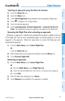
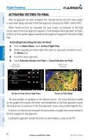
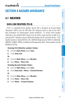
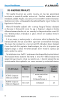
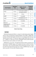
Overview Navigation Flight Planning Hazard Avoidance Additional Features Hazard Avoidance SECTION 4 HAZARD AVOIDANCE 4.1 WEATHER DATA LINK WEATHER (FIS-B) FIS-B is a subscription-free weather service that is broadcast by Ground Based Transceivers (GBTs) over the 978 MHz UAT frequency band as part of the FAA's Next Generation Air Transportation System (NextGen). To receive FIS-B weather information, the weather/traffic device must be within range and line-of-sight of an operating GBT. Reception may be affected by altitude, terrain, and other factors. FIS-B weather products include METARs, TAFs, NEXRAD (Regional and CONUS (Combined)), AIRMETs, SIGMETs, PIREPs, and Winds and Temperatures Aloft. Other products include NOTAMs and TFRs. Viewing FIS-B Weather product Status: 1) From the Main Menu, touch Tools. 2) Touch Data Link Or: 1) From the Main Menu, touch Weather. 2) Touch Menu > More Info. Viewing Ground Station Status: 1) From the Main Menu, touch Tools. 2) Touch Data Link > Menu > Ground Stations. Or: 1) From the Main Menu, touch Weather. 2) Touch Menu > More Info. 3) Touch Menu > Ground Stations. Appendices Index 190-02017-20 Rev. A Garmin aera 660 Pilot's Guide 81
-
 1
1 -
2
-
3
-
4
-
5
-
6
-
7
-
8
-
9
-
10
-
11
-
12
-
13
-
14
-
15
-
16
-
17
-
18
-
19
-
20
-
21
-
22
-
23
-
24
-
25
-
26
-
27
-
28
-
29
-
30
-
31
-
32
-
33
-
34
-
35
-
36
-
37
-
38
-
39
-
40
-
41
-
42
-
43
-
44
-
45
-
46
-
47
-
48
-
49
-
50
-
51
-
52
-
53
-
54
-
55
-
56
-
57
-
58
-
59
-
60
-
61
-
62
-
63
-
64
-
65
-
66
-
67
-
68
-
69
-
70
-
71
-
72
-
73
-
74
-
75
-
76
-
77
-
78
-
79
-
80
-
81
-
82
-
83
-
84
-
85
-
86
-
87
-
88
-
89
-
90
-
91
-
 92
92 -
 93
93 -
 94
94 -
 95
95 -
 96
96 -
 97
97 -
 98
98 -
 99
99 -
 100
100 -
 101
101 -
 102
102 -
103
-
104
-
105
-
106
-
107
-
108
-
109
-
110
-
111
-
112
-
113
-
114
-
115
-
116
-
117
-
118
-
119
-
120
-
121
-
122
-
123
-
124
-
125
-
126
-
127
-
128
-
129
-
130
-
131
-
132
-
133
-
134
-
135
-
136
-
137
-
138
-
139
-
140
-
141
-
142
-
143
-
144
-
145
-
146
-
147
-
148
-
149
-
150
-
151
-
152
-
153
-
154
-
155
-
156
-
157
-
158
-
159
-
160
-
161
-
162
-
163
-
164
-
165
-
166
-
167
-
168
-
169
-
170
-
171
-
172
-
173
-
174
-
175
-
176
-
177
-
178
-
179
-
180
-
181
-
182
-
183
-
184
-
185
-
186
-
187
-
188
-
189
-
190
-
191
-
192
-
193
-
194
-
195
-
196
-
197
-
198
-
199
-
200
-
201
-
202
-
203
-
204
 |
 |
