Garmin aera 660 aera 660 Pilot s Guide - Page 145
Airport Directory Databases, Navigation Database, Appendix C
 |
View all Garmin aera 660 manuals
Add to My Manuals
Save this manual to your list of manuals |
Page 145 highlights
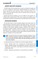
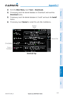
Overview Navigation Flight Planning Hazard Avoidance Additional Features Appendix C AIRPORT DIRECTORY DATABASES The AOPA Airport Directory provides data on airports and heliports throughout the U.S. and it is updated on a 56-day cycle. Detailed information for over 5,300 U.S. airports, along with the names and phone numbers of thousands of FBOs can be viewed. This service allows the pilot to plan an overnight, choose fuel stops, find ground transportation, etc. Optional airport directory databases such as AC-U-KWIK are also supported. ACU-KWIK provides complete listings of FBOs, charter companies, fuel suppliers, ground transportation, maintenance and catering services at public airports across the world. NAVIGATION DATABASE The aera 660 includes an internal navigation database that provides location and facility information for thousands of airports, VORs, NDBs, and more. There are two navigation database products available: the Garmin Navigation database containing coverage for North America (expanded coverage is planned for the future), and the Jeppesen Navigation database containing coverage for the world, available in regionalized options. Database purchases are available online (www.fly.garmin. com). However, once the databases are purchased, the ability to download and install databases is available from the aera 660 via WiFi. NOTE: Although the Garmin and Jeppesen Navigation Databases contain much of the same information, pilots may notice differences in behavior, nearest list functionality, airspace display, and map page display details due to data content variations. The following information is provided from the internal navigation database: • *Airport-identifier, facility name, city/state/country, latitude/longitude, field elevation, available fuel types, runway designations and layout, runway surface, runway length, runway width, runway lighting, communication frequencies, and published approaches. • Weather-frequencies associated with an airport (ASOS, ATIS, and AWOS). Appendices Index 190-02017-20 Rev. A Garmin aera 660 Pilot's Guide 129
-
 1
1 -
2
-
3
-
4
-
5
-
6
-
7
-
8
-
9
-
10
-
11
-
12
-
13
-
14
-
15
-
16
-
17
-
18
-
19
-
20
-
21
-
22
-
23
-
24
-
25
-
26
-
27
-
28
-
29
-
30
-
31
-
32
-
33
-
34
-
35
-
36
-
37
-
38
-
39
-
40
-
41
-
42
-
43
-
44
-
45
-
46
-
47
-
48
-
49
-
50
-
51
-
52
-
53
-
54
-
55
-
56
-
57
-
58
-
59
-
60
-
61
-
62
-
63
-
64
-
65
-
66
-
67
-
68
-
69
-
70
-
71
-
72
-
73
-
74
-
75
-
76
-
77
-
78
-
79
-
80
-
81
-
82
-
83
-
84
-
85
-
86
-
87
-
88
-
89
-
90
-
91
-
92
-
93
-
94
-
95
-
96
-
97
-
98
-
99
-
100
-
101
-
102
-
103
-
104
-
105
-
106
-
107
-
108
-
109
-
110
-
111
-
112
-
113
-
114
-
115
-
116
-
117
-
118
-
119
-
120
-
121
-
122
-
123
-
124
-
125
-
126
-
127
-
128
-
129
-
130
-
131
-
132
-
133
-
134
-
135
-
136
-
137
-
138
-
139
-
 140
140 -
 141
141 -
 142
142 -
 143
143 -
 144
144 -
 145
145 -
 146
146 -
 147
147 -
 148
148 -
 149
149 -
 150
150 -
151
-
152
-
153
-
154
-
155
-
156
-
157
-
158
-
159
-
160
-
161
-
162
-
163
-
164
-
165
-
166
-
167
-
168
-
169
-
170
-
171
-
172
-
173
-
174
-
175
-
176
-
177
-
178
-
179
-
180
-
181
-
182
-
183
-
184
-
185
-
186
-
187
-
188
-
189
-
190
-
191
-
192
-
193
-
194
-
195
-
196
-
197
-
198
-
199
-
200
-
201
-
202
-
203
-
204
 |
 |
