Garmin aera 660 aera 660 Pilot s Guide - Page 190
Appendix J
 |
View all Garmin aera 660 manuals
Add to My Manuals
Save this manual to your list of manuals |
Page 190 highlights
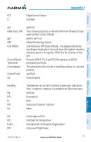
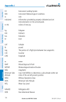
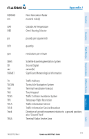
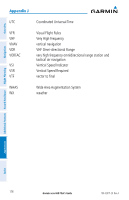
Overview Navigation Additional Features Hazard Avoidance Flight Planning Appendix J Crosstrack Error The distance the aircraft is off a desired course in either direction, left or right. dBZ deg Desired Track DIS Distance DME DTK decibels 'Z' (radar return) degree The desired course between the active "from" and "to" waypoints. distance The 'great circle' distance from the present position to a destination waypoint. Distance Measuring Equipment Desired Track Enroute Safe Altitude The recommended minimum altitude within ten miles left or right of the desired course on an active flight plan or directto. ESA Enroute Safe Altitude Estimated Time of The estimated time at which the aircraft should reach the Arrival destination waypoint, based upon current speed and track. Estimated Time The estimated time it takes to reach the destination waypoint Enroute from the present position, based upon current ground speed. ETA Estimated Time of Arrival ETE Estimated Time Enroute ºF degrees Fahrenheit FAA Federal Aviation Administration FAF Final Approach Fix FCC Federal Communication Commission FIS-B Flight Information Service-Broadcast fpm feet per minute Appendices Index 174 Garmin aera 660 Pilot's Guide 190-02017-20 Rev. A
-
 1
1 -
2
-
3
-
4
-
5
-
6
-
7
-
8
-
9
-
10
-
11
-
12
-
13
-
14
-
15
-
16
-
17
-
18
-
19
-
20
-
21
-
22
-
23
-
24
-
25
-
26
-
27
-
28
-
29
-
30
-
31
-
32
-
33
-
34
-
35
-
36
-
37
-
38
-
39
-
40
-
41
-
42
-
43
-
44
-
45
-
46
-
47
-
48
-
49
-
50
-
51
-
52
-
53
-
54
-
55
-
56
-
57
-
58
-
59
-
60
-
61
-
62
-
63
-
64
-
65
-
66
-
67
-
68
-
69
-
70
-
71
-
72
-
73
-
74
-
75
-
76
-
77
-
78
-
79
-
80
-
81
-
82
-
83
-
84
-
85
-
86
-
87
-
88
-
89
-
90
-
91
-
92
-
93
-
94
-
95
-
96
-
97
-
98
-
99
-
100
-
101
-
102
-
103
-
104
-
105
-
106
-
107
-
108
-
109
-
110
-
111
-
112
-
113
-
114
-
115
-
116
-
117
-
118
-
119
-
120
-
121
-
122
-
123
-
124
-
125
-
126
-
127
-
128
-
129
-
130
-
131
-
132
-
133
-
134
-
135
-
136
-
137
-
138
-
139
-
140
-
141
-
142
-
143
-
144
-
145
-
146
-
147
-
148
-
149
-
150
-
151
-
152
-
153
-
154
-
155
-
156
-
157
-
158
-
159
-
160
-
161
-
162
-
163
-
164
-
165
-
166
-
167
-
168
-
169
-
170
-
171
-
172
-
173
-
174
-
175
-
176
-
177
-
178
-
179
-
180
-
181
-
182
-
183
-
184
-
 185
185 -
 186
186 -
 187
187 -
 188
188 -
 189
189 -
 190
190 -
 191
191 -
 192
192 -
 193
193 -
 194
194 -
 195
195 -
196
-
197
-
198
-
199
-
200
-
201
-
202
-
203
-
204
 |
 |
