Garmin eTrex Legend H Owner's Manual - Page 33
Satellite Map Satellite Options - gps
 |
UPC - 753759084653
View all Garmin eTrex Legend H manuals
Add to My Manuals
Save this manual to your list of manuals |
Page 33 highlights
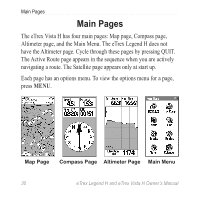
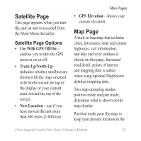
Satellite Page This page appears when you turn the unit on and is accessed from the Main Menu thereafter. Satellite Page Options • Use With GPS Off/On- enables you to turn the GPS receiver on or off. • Track Up/North Up- indicates whether satellites are shown with the rings oriented with North toward the top of the display or your current track toward the top of the screen. • New Location-use if you have moved the unit more than 600 miles (1,000 km). Main Pages • GPS Elevation-shows your current elevation. Map Page A built-in basemap that includes cities, interstates, state and county highways, exit information, and lake and river outlines is shown on this page. Increased road detail, points of interest and mapping data is added when using optional MapSource detailed mapping data. Two map operating modes, position mode and pan mode, determine what is shown on the map display. Position mode pans the map to keep your present location in the eTrex Legend H and eTrex Vista H Owner's Manual 31
-
 1
1 -
2
-
3
-
4
-
5
-
6
-
7
-
8
-
9
-
10
-
11
-
12
-
13
-
14
-
15
-
16
-
17
-
18
-
19
-
20
-
21
-
22
-
23
-
24
-
25
-
26
-
27
-
 28
28 -
 29
29 -
 30
30 -
 31
31 -
 32
32 -
 33
33 -
 34
34 -
 35
35 -
 36
36 -
 37
37 -
 38
38 -
39
-
40
-
41
-
42
-
43
-
44
-
45
-
46
-
47
-
48
-
49
-
50
-
51
-
52
-
53
-
54
-
55
-
56
-
57
-
58
-
59
-
60
-
61
-
62
-
63
-
64
-
65
-
66
-
67
-
68
 |
 |