Garmin eTrex Legend H Owner's Manual - Page 43
Altimeter View Elevation Plot, View Pressure Plot
 |
UPC - 753759084653
View all Garmin eTrex Legend H manuals
Add to My Manuals
Save this manual to your list of manuals |
Page 43 highlights
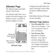
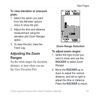
Main Pages Altimeter Page The Altimeter page is provided with the Vista H only. The Altimeter page shows you a profile of elevation changes over distance or time, or a profile of pressure changes over time. Range grid measurement scales Rate of ascent and descent Altimeter Page Configure the profile field in the center of the page to show either elevation or ambient pressure plots. Data fields at the top of the page are user selectable. Altimeter Page Options • View Elevation Plot-Over Time or Over Distance-view over a set period of time or over a set distance. • View Pressure Plot- Barometer or Ambient Pressure-view a plot of elevation changes that occur over a set distance or view changes in barometric pressure for a set period of time. eTrex Legend H and eTrex Vista H Owner's Manual 41
-
 1
1 -
2
-
3
-
4
-
5
-
6
-
7
-
8
-
9
-
10
-
11
-
12
-
13
-
14
-
15
-
16
-
17
-
18
-
19
-
20
-
21
-
22
-
23
-
24
-
25
-
26
-
27
-
28
-
29
-
30
-
31
-
32
-
33
-
34
-
35
-
36
-
37
-
 38
38 -
 39
39 -
 40
40 -
 41
41 -
 42
42 -
 43
43 -
 44
44 -
 45
45 -
 46
46 -
 47
47 -
 48
48 -
49
-
50
-
51
-
52
-
53
-
54
-
55
-
56
-
57
-
58
-
59
-
60
-
61
-
62
-
63
-
64
-
65
-
66
-
67
-
68
 |
 |
