Canon EOS 7D Mark II Instruction Manual - Page 114
Logging the Route Traveled
 |
View all Canon EOS 7D Mark II manuals
Add to My Manuals
Save this manual to your list of manuals |
Page 114 highlights
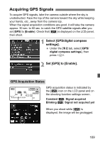
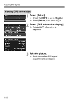
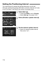
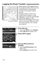
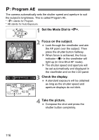
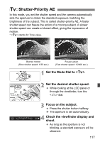
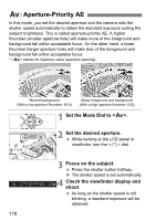
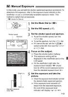
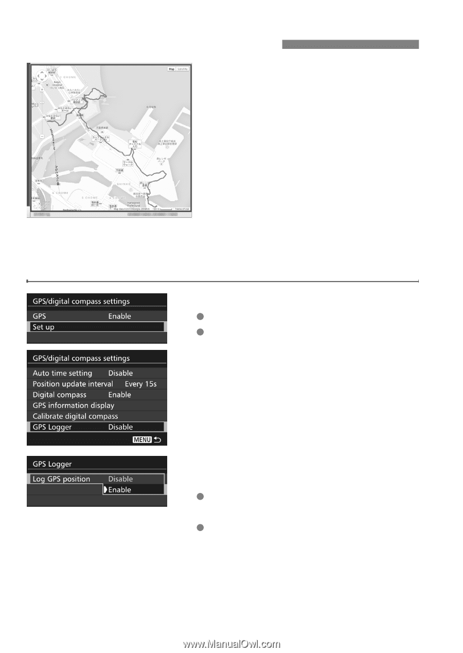
Logging the Route Traveled When using the GPS logging function, the geotag information of the route the camera traveled is automatically recorded in the camera's internal memory. Shooting locations and the route traveled can be viewed on a map displayed on a computer using the Map Utility (EOS software, p.169). Note that the GPS logging function will Map data ©2014 ZENRIN - continue to log information even when the camera's power is off, including auto power off. 1 Select [Set up]. Check that [GPS] is set to [Enable]. Select [Set up], then press . 2 Select [GPS Logger]. 3 Set [Log GPS position] to [Enable]. Select [Log GPS position], then press . Select [Enable], then press . 114
-
 1
1 -
2
-
3
-
4
-
5
-
6
-
7
-
8
-
9
-
10
-
11
-
12
-
13
-
14
-
15
-
16
-
17
-
18
-
19
-
20
-
21
-
22
-
23
-
24
-
25
-
26
-
27
-
28
-
29
-
30
-
31
-
32
-
33
-
34
-
35
-
36
-
37
-
38
-
39
-
40
-
41
-
42
-
43
-
44
-
45
-
46
-
47
-
48
-
49
-
50
-
51
-
52
-
53
-
54
-
55
-
56
-
57
-
58
-
59
-
60
-
61
-
62
-
63
-
64
-
65
-
66
-
67
-
68
-
69
-
70
-
71
-
72
-
73
-
74
-
75
-
76
-
77
-
78
-
79
-
80
-
81
-
82
-
83
-
84
-
85
-
86
-
87
-
88
-
89
-
90
-
91
-
92
-
93
-
94
-
95
-
96
-
97
-
98
-
99
-
100
-
101
-
102
-
103
-
104
-
105
-
106
-
107
-
108
-
 109
109 -
 110
110 -
 111
111 -
 112
112 -
 113
113 -
 114
114 -
 115
115 -
 116
116 -
 117
117 -
 118
118 -
 119
119 -
120
-
121
-
122
-
123
-
124
-
125
-
126
-
127
-
128
-
129
-
130
-
131
-
132
-
133
-
134
-
135
-
136
-
137
-
138
-
139
-
140
-
141
-
142
-
143
-
144
-
145
-
146
-
147
-
148
-
149
-
150
-
151
-
152
-
153
-
154
-
155
-
156
-
157
-
158
-
159
-
160
-
161
-
162
-
163
-
164
-
165
-
166
-
167
-
168
-
169
-
170
-
171
-
172
-
173
-
174
-
175
-
176
-
177
-
178
-
179
-
180
 |
 |
114
When using the GPS logging function,
the geotag information of the route the
camera traveled is automatically
recorded in the camera’s internal
memory.
Shooting locations and the route
traveled can be viewed on a map
displayed on a computer using the Map
Utility (EOS software, p.169).
Note that the GPS logging function will
continue to log information even when
the camera’s power is off, including
auto power off.
1
Select [Set up].
Check that [
GPS
] is set to [
Enable
].
Select [
Set up
], then press <
0
>.
2
Select [GPS Logger].
3
Set [Log GPS position] to
[Enable].
Select [
Log GPS position
], then
press <
0
>.
Select [
Enable
], then press <
0
>.
Logging the Route Traveled
Map data ©2014 ZENRIN -