Garmin GPSMAP 66 Owners Manual
Garmin GPSMAP 66 Manual
 |
View all Garmin GPSMAP 66 manuals
Add to My Manuals
Save this manual to your list of manuals |
Garmin GPSMAP 66 manual content summary:
- Garmin GPSMAP 66 | Owners Manual - Page 1
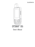
GPSMAP® 66i Owner's Manual - Garmin GPSMAP 66 | Owners Manual - Page 2
of this manual without obligation to notify any person or organization of such changes or improvements. Go to www.garmin.com for current updates and supplemental information concerning the use of this product. Garmin®, the Garmin logo, ANT+®, Auto Lap®, AutoLocate®, GPSMAP®, inReach®, TracBack - Garmin GPSMAP 66 | Owners Manual - Page 3
Connect IQ Features 7 Downloading Connect IQ Features 7 Downloading Connect IQ Features Using Your Computer .... 7 Viewing Connect IQ Widgets 7 Garmin Explore 7 Navigation 7 Navigating to a Destination 7 Navigating with the Map 7 Navigating with the Compass 7 Stopping Navigation 7 Waypoints - Garmin GPSMAP 66 | Owners Manual - Page 4
Appendix 18 Data Fields 18 Getting More Information 20 Optional Accessories 20 tempe 20 Tips for Pairing ANT+ Accessories with Your Garmin Device 20 Troubleshooting 20 Restarting the Device 20 About Heart Rate Zones 20 Fitness Goals 20 Heart Rate Zone Calculations 21 Index 22 ii Table - Garmin GPSMAP 66 | Owners Manual - Page 5
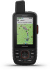
Getting Started WARNING See the Important Safety and Product Information guide in the product box for product warnings and other important information. Device Overview Sending inReach® messages Unread inReach messages Buttons Internal Iridium® and GNSS antenna - Garmin GPSMAP 66 | Owners Manual - Page 6
features of your GPSMAP 66i device, you must activate it. 1 Create an account, and select a satellite subscription at explore.garmin.com. 2 Turn the listen to receive messages. You can force a check for messages by manually checking for messages, sending a message, or sending a track point. During - Garmin GPSMAP 66 | Owners Manual - Page 7
has an older model cell phone that does not support viewing maps or is outside of a mobile data interval. Track points appear on the Garmin Explore website and the MapShare™ Select Send Message. Your reply lets the emergency response service know that you are capable of interacting with them during - Garmin GPSMAP 66 | Owners Manual - Page 8
Garmin Explore app. Changes made to data such as collections, waypoints, routes, and tracks update automatically. You can now sync your data to your GPSMAP 66i device. Contacts You can add, delete, and edit contacts on the GPSMAP 66i you must zoom in or out manually. Detail: Selects the amount of - Garmin GPSMAP 66 | Owners Manual - Page 9
moving long distances or experiencing temperature changes. 1 From the compass, select MENU. 2 Select Calibrate Compass > Start. 3 Follow the on-screen instructions. Heading Settings From the compass, select MENU, and select Heading Setup. Display: Sets the type of directional heading shown on the - Garmin GPSMAP 66 | Owners Manual - Page 10
services to view live geocache data from www.geocaching.com using the Garmin Connect Garmin Explore account. Phone notifications: Displays phone notifications and messages on your GPSMAP 66 series device using the Garmin manage notifications that appear on your GPSMAP 66i device. Select an option: • - Garmin GPSMAP 66 | Owners Manual - Page 11
pair your GPSMAP 66i device with your smartphone (Pairing a Smartphone with Your Device, page 6). 1 From the app store on your smartphone, install and open the Connect IQ app. 2 If necessary, select your device. 3 Select a Connect IQ feature. 4 Follow the on-screen instructions. Downloading Connect - Garmin GPSMAP 66 | Owners Manual - Page 12
Projecting a Waypoint You can create a new location by projecting the distance and bearing from a marked location to a new location. 1 Select Waypoint Manager. 2 Select a waypoint. 3 Select MENU > Project Waypoint. 4 Enter the bearing, and select Done. 5 Select a unit of measure. 6 Enter the - Garmin GPSMAP 66 | Owners Manual - Page 13
recording manually. 1 Garmin devices. 1 Select Recorded Activities. 2 Select an activity. 3 Select MENU > Save as Track. Weather Your GPSMAP 66 device can receive weather information using two different services. You can receive weather for your current location. Active Weather: While your GPSMAP 66i - Garmin GPSMAP 66 | Owners Manual - Page 14
forecast. 3 Select Delete. Viewing an Active Weather Forecast While your GPSMAP 66 device is connected to your smartphone or to a Wi‑Fi network Use and History You can view plan details and data use on the GPSMAP 66i device. Viewing Plan Details 1 Select inReach Utilities. 2 Select Plan Details. - Garmin GPSMAP 66 | Owners Manual - Page 15
controls when you have a VIRB® device paired with your GPSMAP 66 series device (Using the VIRB Remote, page 13). Stopwatch Garmin Connect app (Pairing a Smartphone with Your Device, page 6). 2 Select Setup > Geocaching > Register Device. An activation code appears. 3 Follow the on-screen instructions - Garmin GPSMAP 66 | Owners Manual - Page 16
Done. If you are signed in to www.geocaching.com, the log uploads to your www.geocaching.com account automatically. chirp A chirp is a small Garmin accessory that is programmed and left in a geocache. You can use your device to find a chirp in a geocache. Enabling chirp Searching 1 Select Setup - Garmin GPSMAP 66 | Owners Manual - Page 17
. 3 Follow the on-screen instructions. Selecting a Profile When you change camera. See the VIRB Series Owner's Manual for more information. The VIRB remote function Turn on your VIRB camera. 2 On your GPSMAP 66 series device, select VIRB Remote. 3 Wait position using the Garmin AutoLocate® feature. - Garmin GPSMAP 66 | Owners Manual - Page 18
WAAS/EGNOS: Enables the system to use Wide Area Augmentation System/European Geostationary Navigation Overlay Service (WAAS/EGNOS) data. Serial Interface Settings Select Setup > System > Interface. Garmin Spanner: Allows you to use the device USB port with most NMEA 0183-compliant mapping programs - Garmin GPSMAP 66 | Owners Manual - Page 19
Sensors Your device can be used with wireless ANT+ or Bluetooth sensors. For more information about compatibility and purchasing optional sensors, go to buy.garmin.com. Pairing Your Wireless Sensors Before you can pair, you must put on the heart rate monitor or install the sensor. Pairing is the - Garmin GPSMAP 66 | Owners Manual - Page 20
Page Sequence: Allows you to move, add, and delete items in the page sequence (Changing the Page Sequence, page 16). Setup: Changes the order of items in the setup menu. Find: Changes the order of items in the find menu. Customizing the Main Menu You can move, add, and delete items in the main menu. - Garmin GPSMAP 66 | Owners Manual - Page 21
More Information You can find more information about this product on the Garmin website. • Go to support.garmin.com for additional manuals, articles, and software updates. • Go to buy.garmin.com, or contact your Garmin dealer for information about optional accessories and replacement parts. Battery - Garmin GPSMAP 66 | Owners Manual - Page 22
compatible with Windows® 95, 98, Me, Windows NT®, and Mac® OS 10.3 and earlier. File Types The handheld device supports these file types: • Files from Garmin Explore. • GPX route, track, and waypoint files. • GPX geocache files (Downloading Geocaches Using a Computer, page 11). • JPEG photo files - Garmin GPSMAP 66 | Owners Manual - Page 23
Ascent - Average: The average vertical distance of ascent since the last reset. Ascent - Maximum: The maximum rate of ascent in feet per minute or meters per minute since the last reset. Ascent - Total: The total elevation distance ascended during the activity or since the last reset. Automotive - Garmin GPSMAP 66 | Owners Manual - Page 24
Garmin website. • Go to support.garmin.com for additional manuals, articles, and software updates. • Go to buy.garmin.com, or contact your Garmin • When paired, your Garmin device receives data from only your accessory, and you can go near other accessories. Troubleshooting Restarting the Device If - Garmin GPSMAP 66 | Owners Manual - Page 25
Heart Rate Zone Calculations Zone % of Maximum Heart Rate Perceived Exertion Benefits 1 50-60% Relaxed, easy pace, rhythmic breathing Beginning-level aerobic training, reduces stress 2 60-70% Comfortable pace, slightly deeper breathing, conversation possible Basic cardiovascular training, - Garmin GPSMAP 66 | Owners Manual - Page 26
transferring 11, 18 fitness 15 flashlight 10, 13 G Garmin Connect 6 Garmin Explore 18 Garmin Express 17 updating software 17 gauges, trip 4 22 geocaches computer 5 trip gauges 4 trip information, viewing 5 trip planner. See routes troubleshooting 16, 17, 20 U units of measure 16 USB 14 connector 1 - Garmin GPSMAP 66 | Owners Manual - Page 27
- Garmin GPSMAP 66 | Owners Manual - Page 28
support.garmin.com June 2020 GUID-A921AB4F-381A-48D5-9BCC-9A895445C84F v3
-
 1
1 -
 2
2 -
 3
3 -
 4
4 -
 5
5 -
 6
6 -
 7
7 -
8
-
9
-
10
-
11
-
12
-
13
-
14
-
15
-
16
-
17
-
18
-
19
-
20
-
21
-
22
-
23
-
24
-
25
-
26
-
27
-
28
 |
 |

GPSMAP
®
66i
Owner’s Manual