Garmin GPSMAP 66 Owners Manual - Page 17
Sending and Receiving Data Wirelessly
 |
View all Garmin GPSMAP 66 manuals
Add to My Manuals
Save this manual to your list of manuals |
Page 17 highlights
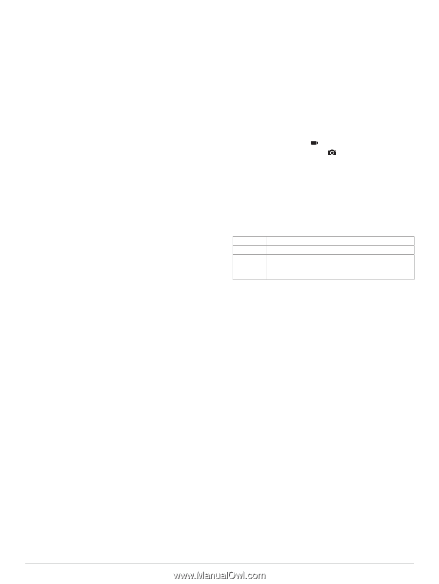
When you are within approximately 10 m (33 ft.) of the geocache that contains a chirp, details about the chirp appear. 2 Select Show Details. 3 If necessary, select Go to navigate to the next stage of the geocache. Removing Live Geocache Data from the Device You can remove live geocache data to show only geocaches manually loaded on the device using a computer. Select Setup > Geocaching > Geocaching Live > Remove Live Data. Live geocaching data is removed from the device and no longer appears in the geocache list. Removing Your Device Registration From Geocaching.com If you transfer ownership of your device, you can remove your device registration from the geocaching website. Select Setup > Geocaching > Geocaching Live > Unregister Device. Setting a Proximity Alarm Proximity alarms alert you when you are within a specified range of a particular location. 1 Select Proximity Alarms > Create Alarm. 2 Select a category. 3 Select a location. 4 Select Use. 5 Enter a radius. When you enter an area with a proximity alarm, the device sounds a tone. Editing or Deleting a Proximity Alarm 1 Select Proximity Alarms. 2 Select an alarm. 3 Select an option: • To edit the radius, select Change Radius. • To view the alarm on a map, select View Map. • To delete the alarm, select Delete. Sending and Receiving Data Wirelessly Before you can share data wirelessly, you must be within 3 m (10 ft.) of a compatible Garmin device. Your device can send and receive data wirelessly when connected with a compatible Garmin device using ANT+ technology. You can share waypoints, geocaches, routes, tracks, and more. 1 Select Share Wirelessly. 2 Select an option: • Select Send, and select a type of data. • Select Receive to receive data from another device. The other compatible device must be attempting to send data. 3 Follow the on-screen instructions. Selecting a Profile When you change activities, you can change the setup of the device by changing the profile. 1 Select Profile Change. 2 Select a profile. Calculating the Size of an Area 1 Select Area Calculation > Start. 2 Walk around the perimeter of the area you want to calculate. 3 Select Calculate when finished. Using the VIRB Remote Before you can use the VIRB remote function, you must enable the remote setting on your VIRB camera. See the VIRB Series Owner's Manual for more information. The VIRB remote function allows you to control your VIRB action camera using your device. 1 Turn on your VIRB camera. 2 On your GPSMAP 66 series device, select VIRB Remote. 3 Wait while the device connects to your VIRB camera. 4 Select an option: • To record video, select . • To take a photograph, select . Using the Flashlight NOTE: Using the flashlight can reduce battery life. You can reduce the brightness or flash frequency to extend the life of the battery. 1 Select Flashlight > ENTER. 2 If necessary, use the brightness slider to adjust the brightness. 3 If necessary, select a different flash type. 0 No strobe, constant beam. 1 through 9 Number of strobes per second. SOS Emergency strobe. NOTE: Wi‑Fi, Bluetooth, and ANT+ connections are disabled in SOS mode. Satellite Page The satellite page shows your current location, GPS accuracy, satellite locations, and signal strength. GPS Satellite Settings Select Satellite > MENU. Use With GPS On: Allows you to turn the GPS on. Track Up: Indicates whether satellites are shown with rings oriented with north toward the top of the screen or oriented with your current track toward the top of the screen. Single Color: Allows you to select whether the satellite page is displayed in multicolor or single color. Set Location On Map: Allows you to mark your current location on the map. You can use this location to create routes or search for saved locations. AutoLocate Position: Calculates your GPS position using the Garmin AutoLocate® feature. Satellite Setup: Sets the satellite system options (Satellite Settings, page 14). Customizing the Device Customizing the Data Fields You can customize the data fields displayed on each main page. 1 Open the page for which you will change the data fields. 2 Select MENU. 3 Select Change Data Fields. 4 Select the new data field. 5 Follow the on-screen instructions. Customizing the Device 13
-
 1
1 -
2
-
3
-
4
-
5
-
6
-
7
-
8
-
9
-
10
-
11
-
 12
12 -
 13
13 -
 14
14 -
 15
15 -
 16
16 -
 17
17 -
 18
18 -
 19
19 -
 20
20 -
 21
21 -
 22
22 -
23
-
24
-
25
-
26
-
27
-
28
 |
 |