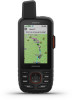
Garmin GPSMAP 66 Owners Manual - Page 24
Getting More Information, Optional Accessories, Troubleshooting, About Heart Rate Zones
 |
View all Garmin GPSMAP 66 manuals
Add to My Manuals
Save this manual to your list of manuals |
Page 24 highlights
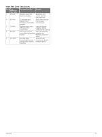
Speed - Overall Avg.: The average speed while moving and stopped since the last reset. Stopwatch Timer: The stopwatch time for the current activity. Sunrise: The time of sunrise based on your GPS position. Sunset: The time of sunset based on your GPS position. Temperature: The temperature of the air. Your body temperature affects the temperature sensor. Your device must be connected to a tempe™ sensor for this data to appear. Temperature - Water: The temperature of the water. Your device must be connected to a NMEA 0183 device capable of acquiring the water temperature. Time of Day: The time of day based on your current location and time settings (format, time zone, daylight saving time). Time to Destination: The estimated time remaining before you reach the destination. You must be navigating for this data to appear. Time to Next: The estimated time remaining before you reach the next waypoint in the route. You must be navigating for this data to appear. To Course: The direction in which you must move to get back on the route. You must be navigating for this data to appear. Total Lap: The stopwatch time for all the completed laps. Trip Odometer: A running tally of the distance traveled since the last reset. Trip Time: A running tally of the total time spent moving and not moving since the last reset. Trip Time - Moving: A running tally of the time spent moving since the last reset. Trip Time - Stopped: A running tally of the time spent not moving since the last reset. Turn: The angle of difference (in degrees) between the bearing to your destination and your current course. L means turn left. R means turn right. You must be navigating for this data to appear. Velocity Made Good: The speed at which you are closing on a destination along a route. You must be navigating for this data to appear. Vertical Dist. to Dest.: The elevation distance between your current position and the final destination. You must be navigating for this data to appear. Vertical Dist. to Next: The elevation distance between your current position and the next waypoint in the route. You must be navigating for this data to appear. Vertical Speed: The rate of ascent or descent over time. Vertical Speed to Dest.: The rate of ascent or descent to a predetermined altitude. You must be navigating for this data to appear. Waypoint at Dest.: The last point on the route to the destination. You must be navigating for this data to appear. Waypoint at Next: The next point on the route. You must be navigating for this data to appear. Getting More Information You can find more information about this product on the Garmin website. • Go to support.garmin.com for additional manuals, articles, and software updates. • Go to buy.garmin.com, or contact your Garmin dealer for information about optional accessories and replacement parts. Optional Accessories Optional accessories, such as mounts, maps, fitness accessories, and replacement parts, are available at http://buy.garmin.com or from your Garmin dealer. tempe The tempe is an ANT+ wireless temperature sensor. You can attach the sensor to a secure strap or loop where it is exposed to ambient air, and therefore, provides a consistent source of accurate temperature data. You must pair the tempe with your device to display temperature data from the tempe. Tips for Pairing ANT+ Accessories with Your Garmin Device • Verify that the ANT+ accessory is compatible with your Garmin device. • Before you pair the ANT+ accessory with your Garmin device, move 10 m (33 ft.) away from other ANT+ accessories. • Bring the Garmin device within range 3 m (10 ft.) of the ANT+ accessory. • After you pair the first time, your Garmin device automatically recognizes the ANT+ accessory each time it is activated. This process occurs automatically when you turn on the Garmin device and only takes a few seconds when the accessories are activated and functioning correctly. • When paired, your Garmin device receives data from only your accessory, and you can go near other accessories. Troubleshooting Restarting the Device If the device stops responding, you may need to restart it. This does not erase any of your data or settings. Hold the power button for approximately 30 seconds. About Heart Rate Zones Many athletes use heart rate zones to measure and increase their cardiovascular strength and improve their level of fitness. A heart rate zone is a set range of heartbeats per minute. The five commonly accepted heart rate zones are numbered from 1 to 5 according to increasing intensity. Generally, heart rate zones are calculated based on percentages of your maximum heart rate. Fitness Goals Knowing your heart rate zones can help you measure and improve your fitness by understanding and applying these principles. • Your heart rate is a good measure of exercise intensity. • Training in certain heart rate zones can help you improve cardiovascular capacity and strength. If you know your maximum heart rate, you can use the table (Heart Rate Zone Calculations, page 21) to determine the best heart rate zone for your fitness objectives. If you do not know your maximum heart rate, use one of the calculators available on the Internet. Some gyms and health centers can provide a test that measures maximum heart rate. The default maximum heart rate is 220 minus your age. 20 Appendix
-
 1
1 -
2
-
3
-
4
-
5
-
6
-
7
-
8
-
9
-
10
-
11
-
12
-
13
-
14
-
15
-
16
-
17
-
18
-
 19
19 -
 20
20 -
 21
21 -
 22
22 -
 23
23 -
 24
24 -
 25
25 -
 26
26 -
 27
27 -
 28
28
 |
 |