Garmin GPSMAP 76CSx Owner's Manual - Page 26
Track Profiles - delete all waypoints
 |
UPC - 753759051648
View all Garmin GPSMAP 76CSx manuals
Add to My Manuals
Save this manual to your list of manuals |
Page 26 highlights
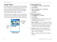
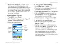
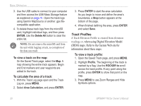
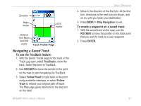
Basic Operation 3. Use the USB cable to connect to your computer and then access the USB Mass Storage feature as explained on page 41. Open the track logs using Garmin MapSource or another .gpx filecompatible application. 4. To delete these track logs from the microSD card, highlight individual logs, and then press ENTER. Use the Delete All button to clear the entire list. Note: Do not remove the microSD card from the unit while logging a track, as corruption of the data can result. To view a track on the map: On the Saved Track page, select the Map. A map showing the entire track appears. Begin and End markers and user waypoints are added to the track. To calculate the area of a track: 1. With the Track Log page open and the Track Log on, press MENU. 2. Select Area Calculation, and press ENTER. 3. Press ENTER to start the area calculation. As you begin to move and define the area's boundaries, a Stop button appears at the bottom of the page. 4. When finished defining the area, press ENTER and select Save. Track Profiles A Track Elevation Profile is created from elevation readings or, when using Digital Elevation Model (DEM) maps. Refer to the Garmin Web site for information about these maps. To view a track profile: 1. Open the Saved Track page, and press MENU. 2. Highlight Profile. The beginning of the track is marked by a flag. Use the ROCKER to scroll across the track profile. At any point along the profile, press ENTER to show that point on the map. 3. Press MENU to use Zoom Ranges and Hide Symbols options. 20 GPSMAP 76CSx Owner's Manual
-
 1
1 -
2
-
3
-
4
-
5
-
6
-
7
-
8
-
9
-
10
-
11
-
12
-
13
-
14
-
15
-
16
-
17
-
18
-
19
-
20
-
 21
21 -
 22
22 -
 23
23 -
 24
24 -
 25
25 -
 26
26 -
 27
27 -
 28
28 -
 29
29 -
 30
30 -
 31
31 -
32
-
33
-
34
-
35
-
36
-
37
-
38
-
39
-
40
-
41
-
42
-
43
-
44
-
45
-
46
-
47
-
48
-
49
-
50
-
51
-
52
-
53
-
54
-
55
-
56
-
57
-
58
-
59
-
60
-
61
-
62
-
63
-
64
 |
 |
