Garmin dezl OTR710 Owners Manual - Page 25
Finding Emergency Services and Fuel, Getting Directions to Your Current Location, Saving Locations
 |
View all Garmin dezl OTR710 manuals
Add to My Manuals
Save this manual to your list of manuals |
Page 25 highlights
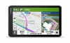
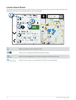
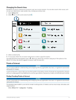
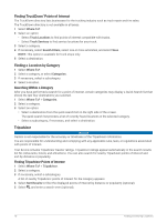
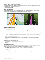
Finding Emergency Services and Fuel You can use the Where Am I? page to find the nearest hospitals, police stations, and fuel stations. 1 From the map, select the vehicle. 2 Select Hospitals, Police Stations, or Fuel. NOTE: When a truck vehicle profile is active, an option for truck stops appears instead of fuel. A list of locations for the selected service appears, with the nearest locations at the top. 3 Select a location. 4 Select an option: • To navigate to the location, select Go! • To view the phone number and other location details, select . Getting Directions to Your Current Location If you need to tell another person how to get to your current location, your device can give you a list of directions. 1 From the map, select the vehicle. 2 Select > Directions to Me. 3 Select a starting location. 4 Select Select. Saving Locations Saving a Location 1 Search for a location (Finding a Location by Category, page 16). 2 From the search results, select a location. 3 Select > Save. 4 If necessary, enter a name, and select Done. 5 Select Save. Saving Your Current Location 1 From the map, select the vehicle icon. 2 Select Save. 3 Enter a name, and select Done. Editing a Saved Location 1 Select Where To? > Saved. 2 If necessary, select a category. 3 Select a location. 4 Select . 5 Select > Edit. 6 Select an option: • Select Name. • Select Phone Number. • Select Categories to assign categories to the saved location. • Select Map Symbol to change the symbol used to mark the saved location on a map. 7 Edit the information. 8 Select Done. Finding and Saving Locations 19
-
 1
1 -
2
-
3
-
4
-
5
-
6
-
7
-
8
-
9
-
10
-
11
-
12
-
13
-
14
-
15
-
16
-
17
-
18
-
19
-
 20
20 -
 21
21 -
 22
22 -
 23
23 -
 24
24 -
 25
25 -
 26
26 -
 27
27 -
 28
28 -
 29
29 -
 30
30 -
31
-
32
-
33
-
34
-
35
-
36
-
37
-
38
-
39
-
40
-
41
-
42
-
43
-
44
-
45
-
46
-
47
-
48
-
49
-
50
-
51
-
52
-
53
-
54
-
55
-
56
-
57
-
58
-
59
-
60
-
61
-
62
-
63
-
64
-
65
-
66
-
67
-
68
-
69
-
70
-
71
-
72
-
73
-
74
-
75
-
76
 |
 |
