Canon PowerShot SX40 HS Software Guide for Windows - Page 37
GPS, Using GPS Information – Map Utility
 |
View all Canon PowerShot SX40 HS manuals
Add to My Manuals
Save this manual to your list of manuals |
Page 37 highlights
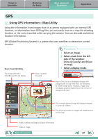
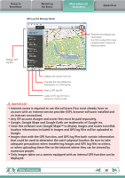
Things to Remember Mastering the Basics More Advanced Techniques Appendices GPS Using GPS Information - Map Utility Using the information from images shot on a camera equipped with an internal GPS function, or information from GPS log files, you can easily view on a map the shooting location, or the route travelled while carrying the camera. You can also add and delete location information. GPS (Global Positioning System) is a system that uses satellites to determine current location. Route View/Edit Mode Procedures 1 Select an image. 2 Select a task from the left side of the window: [View & Classify] and [View on map]. 3 Select a display mode. The image selected in ZoomBrowser EX will display. Input a location to search. Exports files for use in displaying images with Google Earth. To use these files, it is necessary to install Google Earth. However, images may not display properly depending on the version of Google Earth used. The currently selected image will display enlarged, in a pop-up window. The shooting location of images will display as pins on the map. Adds or deletes an image's location information. Adds an image. Table of Contents 37
-
 1
1 -
2
-
3
-
4
-
5
-
6
-
7
-
8
-
9
-
10
-
11
-
12
-
13
-
14
-
15
-
16
-
17
-
18
-
19
-
20
-
21
-
22
-
23
-
24
-
25
-
26
-
27
-
28
-
29
-
30
-
31
-
 32
32 -
 33
33 -
 34
34 -
 35
35 -
 36
36 -
 37
37 -
 38
38 -
 39
39 -
 40
40 -
 41
41 -
 42
42 -
43
-
44
-
45
-
46
-
47
-
48
-
49
-
50
-
51
-
52
-
53
-
54
-
55
-
56
-
57
-
58
-
59
-
60
-
61
-
62
 |
 |