Celestron Omni CG-4 Telescope Mount Astronomy Basics - Page 1
Celestron Omni CG-4 Telescope Mount Manual
 |
View all Celestron Omni CG-4 Telescope Mount manuals
Add to My Manuals
Save this manual to your list of manuals |
Page 1 highlights
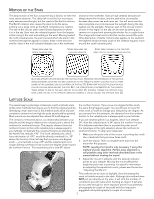
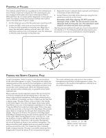
Astronomy Basics English The Celestial Coordinate System and Motion of the Stars sections below are applicable to all types of telescopes, and if you have a non-computerized altazimuth telescope, these are the only sections that apply to your telescope. The sections about Latitude Scale/Pointing at Polaris/Finding the North & South Celestial Poles/Polar Alignment in the Northern & Southern Hemisphere, etc. are basic information for non-computerized equatorially mounted telescopes - actual telescope models may differ somewhat from the descriptions about basic functions. The Celestial Coordinate System To help find objects in the sky, astronomers use a celestial coordinate system that is similar to our geographical coordinate system here on Earth. The celestial coordinate system has poles, lines of longitude and latitude, and an equator. For the most part, these remain fixed against the background stars. The celestial equator runs 360 degrees around the Earth and separates the northern celestial hemisphere from the southern. Like the Earth's equator, it bears a reading of zero degrees. On Earth this would be latitude. However, in the sky this is referred to as declination, or DEC for short. Lines of declination are named for their angular distance above and below the celestial equator. The lines are broken down into degrees, minutes of arc, and seconds of arc. Declination readings south of the equator carry a minus sign (-) in front of the coordinate and those north of the celestial equator are either blank (i.e., no designation) or preceded by a plus sign (+). The celestial equivalent of longitude is called Right Ascension (or R.A. for short). Like the Earth's lines of longitude, they run from pole to pole and are evenly spaced 15 degrees apart. Although the longitude lines are separated by an angular distance, they are also a measure of time. Each line of longitude is one hour apart from the next. Since the Earth rotates once every 24 hours, there are 24 lines total. As a result, the R.A. coordinates are marked off in units of time. It begins with an arbitrary point in the constellation of Pisces designated as 0 hours, 0 minutes, 0 seconds. All other points are designated by how far (i.e., how long) they lag behind this coordinate after it passes overhead moving toward the west. 60 23 22 21 20 19 18 17 40 20 0 1 23 -40 -60 0 The celestial sphere seen from the outside showing R.A. and DEC 1
-
 1
1 -
 2
2 -
 3
3 -
 4
4 -
 5
5 -
 6
6 -
 7
7 -
8
-
9
-
10
-
11
-
12
-
13
-
14
-
15
-
16
-
17
-
18
-
19
-
20
-
21
-
22
-
23
-
24
-
25
-
26
-
27
-
28
-
29
-
30
-
31
-
32
-
33
-
34
-
35
 |
 |