Garmin GPSMAP 2206 Owner's Manual - Page 67
Units Sub Tab, Beeper, Alarms Only, Key and Alarm, Language, System Info, Update Notes
 |
UPC - 753759053024
View all Garmin GPSMAP 2206 manuals
Add to My Manuals
Save this manual to your list of manuals |
Page 67 highlights
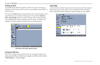
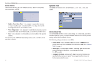
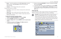
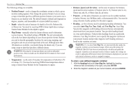
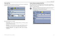
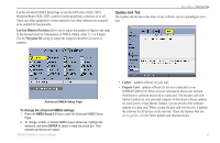
• Beeper-controls the audible beep. Select Off, Alarms Only (sounds for alarms/messages), or Key and Alarm (sounds for key presses and alarms/messages). • Language-sets the language for the unit's on-screen text. The following soft keys are available: • System Info-shows the unit's software, basemap version, and electronic serial number. • Update Notes-shows software notes for the current software version. • Factory Dflts-restores all settings to Garmin's original setup values for all devices on the network. To adjust the automatic backlight settings: 1. Highlight the Automatic Backlight field, and press ENTER. 2. Using the ROCKER, highlight On, and press ENTER. 3. Highlight the Setup button, and press ENTER to open the Adjust Backlight window. 4. To adjust the backlight levels For Day and For Night, highlight the corresponding slider, and press ENTER. Sliders Main Menu > System Tab 5. Press up or down on the ROCKER to increase or decrease the backlight level, and press ENTER. 6. To adjust the offset minutes, select the minutes field, and press ENTER. 7. Enter the offset minutes for Before Sunrise or After Sunset. If zero, the unit automatically changes to the specified level at sunrise/sunset. Press QUIT to exit. Units Sub Tab Use the Units sub tab to define settings for Position Format, Depth, Map Datum, Temperature, Distance, Speed, and Elevation, Pressure, and Heading. Warning: The Units sub tab settings affect how navigation information appears on the GPSMAP 2206/2210. If you are using a map or chart with your GPS, make sure the settings on the Units sub tab match that of the map or chart. This information should be shown somewhere on the map or chart. If not, contact the map or chart maker to determine what position format, datum, heading, and units of measure are used for the map or chart. GPSMAP 2206/2210 Owner's Manual 59
-
 1
1 -
2
-
3
-
4
-
5
-
6
-
7
-
8
-
9
-
10
-
11
-
12
-
13
-
14
-
15
-
16
-
17
-
18
-
19
-
20
-
21
-
22
-
23
-
24
-
25
-
26
-
27
-
28
-
29
-
30
-
31
-
32
-
33
-
34
-
35
-
36
-
37
-
38
-
39
-
40
-
41
-
42
-
43
-
44
-
45
-
46
-
47
-
48
-
49
-
50
-
51
-
52
-
53
-
54
-
55
-
56
-
57
-
58
-
59
-
60
-
61
-
 62
62 -
 63
63 -
 64
64 -
 65
65 -
 66
66 -
 67
67 -
 68
68 -
 69
69 -
 70
70 -
 71
71 -
 72
72 -
73
-
74
-
75
-
76
-
77
-
78
-
79
-
80
-
81
-
82
-
83
-
84
-
85
-
86
-
87
-
88
-
89
-
90
-
91
-
92
-
93
-
94
-
95
-
96
-
97
-
98
-
99
-
100
-
101
-
102
-
103
-
104
-
105
-
106
 |
 |
