Magellan MobileMapper CX Getting Started Guide - Page 23
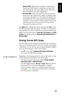
Viewing Current GPS Status, Programs>GPS Utilities>GPS Status - 10
 |
UPC - 009905860047
View all Magellan MobileMapper CX manuals
Add to My Manuals
Save this manual to your list of manuals |
Page 23 highlights
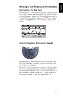
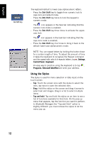
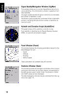
English - Minimum SNR: SNR stands for Signal-to-Noise Ratio. Ensure your SNR mask is not set too low (less than 20). GPS signals with lower SNRs will be very noisy and contribute to accuracy degradation. - Elevation Mask: Angle that specifies that any satellite must be at least a specified number of degrees above the horizon (typically 5 to 10°) before the signals from the satellite are to be used. Ensure that the elevation mask set in your receiver is high enough to avoid using satellites near the horizon as they are often noisier than satellites higher overhead. Tap Apply after making your choice and then tap OK to close the GPS Settings utility. By default, the GPS is configured to track satellites in normal conditions of reception (Open Sky). NOTE: The first three options (Open Sky, Tree Canopy and Urban Canyon) use preset values for Maximum DOP, Minimum SNR and Elevation Mask. Viewing Current GPS Status The GPS Status utility allows you to quickly see if the GPS receiver is calculating a position from the currently visible GPS constellation. It can also be used to log and playback NMEA data. Do the following to launch GPS Status: - Tap , then select Programs>GPS Utilities>GPS Status. This opens the GPS Status window. Regardless of the displayed tab, the bar at the bottom of the screen displays the following, from left to right: - The type of position being calculated (Fix Not Available, Autonomous GPS or Differential GPS). - The data logging status (No Log or Log:x.. xK where x.. x is the current size of the file being logged, in kbytes). - Position indicator light (Blue: Differential GPS position computed; Green: Autonomous GPS position computed; Red: No position computed). 15
-
 1
1 -
2
-
3
-
4
-
5
-
6
-
7
-
8
-
9
-
10
-
11
-
12
-
13
-
14
-
15
-
16
-
17
-
 18
18 -
 19
19 -
 20
20 -
 21
21 -
 22
22 -
 23
23 -
 24
24 -
 25
25 -
 26
26 -
 27
27 -
 28
28 -
29
-
30
-
31
-
32
-
33
-
34
-
35
-
36
-
37
-
38
-
39
-
40
-
41
-
42
-
43
-
44
-
45
-
46
-
47
-
48
-
49
-
50
-
51
-
52
-
53
-
54
-
55
-
56
-
57
-
58
-
59
-
60
-
61
-
62
-
63
-
64
-
65
-
66
-
67
-
68
-
69
-
70
-
71
-
72
-
73
-
74
-
75
-
76
-
77
-
78
-
79
-
80
-
81
-
82
-
83
-
84
-
85
-
86
 |
 |