Motorola V3X User Manual - Page 4
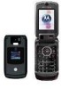
Introduction - phone
 |
View all Motorola V3X manuals
Add to My Manuals
Save this manual to your list of manuals |
Page 4 highlights
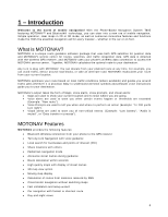
1 - Introduction Welcome to the world of mobile navigation! With the Phone-Based Navigation System T805 featuring MOTONAV™ and Bluetooth® technology, you can steer into a new era of mobile navigation. Simple operation, clear maps in 2D or 3D mode, as well as numerous innovative features and functions make the T805 the essential navigation aid for every traveler - whether in the car or on foot. What is MOTONAV? MOTONAV is a unique route guidance software package that uses both GPS satellites for position data and MOTONAV's service center for routes, searches, and traffic congestion data. GPS data is obtained with the wireless GPS receiver, and MOTONAV uses your phone's wireless data connection to access the MOTONAV service center. Together, MOTONAV calculates the optimal route to your destination. Any turn is okay with MOTONAV. You can deviate from your planned route at any time. For example, you can avoid traffic, detour around road blocks, or take an alternate road. MOTONAV recalculates your route from your current location. MOTONAV optimizes your route based on local traffic conditions (where available) and guides you around traffic jams wherever it is practical. Easy to understand direction symbols and pleasant voice instructions guide you to your destination. MOTONAV's output takes the form of Maps, Voice alerts, Voice prompts, and Visual alerts: • Maps are used to show your current location and to show where you are going. • Voice alerts are used to warn you when certain events happen or thresholds are exceeded (Example: "New route"). • Voice Prompts are used to tell you when and where to perform an action (Example: "In 200 yards turn right"). • Visual alerts are used to warn you of non-critical events. (Example: "Low battery", "Audio is muted", or "Data transfer in process"). MOTONAV Features MOTONAV provides the following features: • Bluetooth Wireless connection from your phone to the GPS receiver • Turn-by-turn Navigation with voice guidance • Local search for businesses and points of interest (POI) • Share locations with others • Pedestrian navigation mode • Announce street names during guidance • Route calculation within seconds • High quality maps with display of street names • 3D map view option • Moving map display • Calculation of routes from locations received by SMS • Cross border navigation without switching maps • Fast installation and setup wizard • Car navigation with fastest or shortest route • Day and night views 4
-
 1
1 -
 2
2 -
 3
3 -
 4
4 -
 5
5 -
 6
6 -
 7
7 -
 8
8 -
 9
9 -
 10
10 -
11
-
12
-
13
-
14
-
15
-
16
-
17
-
18
-
19
-
20
-
21
-
22
-
23
-
24
-
25
-
26
-
27
-
28
-
29
-
30
-
31
-
32
-
33
-
34
-
35
-
36
-
37
-
38
-
39
-
40
-
41
-
42
-
43
-
44
-
45
-
46
 |
 |
