2013 Nissan Pathfinder Navigation System Owner's Manual - Page 145
2013 Nissan Pathfinder Manual

Page 145 highlights
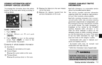
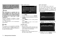
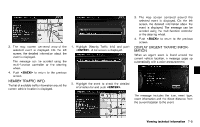
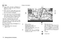
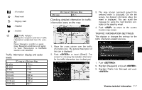
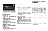
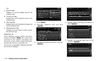
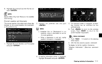
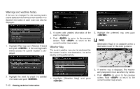
: Information : Road work : Slippery road : Weather : Incident 4 * 1/64 mile 2D map and Birdview Map 25 m Checking detailed information for traffic information icons on the map GUID-5416B9B3-3112-4538-85DE-DE6BFC9FDD6E 3. The map screen centered around the selected event is displayed. On the left screen, the detailed information about the event is displayed. You can scroll the message by using the multi-function controller or the steering wheel. 4. Push to return to the current location map screen. Traffic indicator: Displays the reception condition of traffic information transmitted from the provider. Green: Reception condition is good. Gray: Reception condition is not good. No mark: Subscription to NavTraffic service is not detected. TRAFFIC INFORMATION SETTINGS GUID-8D20AE05-3C79-4292-878D-64ABF082163E This displays or changes the settings for the traffic information related functions. NIN0007 1. Place the cross pointer over the traffic information icon. The general description of the icon is displayed. 2. Push or touch [Detail]. The screen for showing the detailed information for the traffic information icon is displayed. 1. Push . NIN0037 Traffic information display and scale levels GUID-B918E77A-07C7-4047-B349-ED8C636EAB44 5 miles 2 miles 1 mile 1/2 mile 1/4 mile 1/8 mile 1/16 mile 1/32 mile 2D map and Birdview Map 10 km 4 km 2 km 1 km 500 m 200 m 100 m 50 m 2. Highlight [Navigation] and push . 3. Highlight [Traffic Info Settings] and push . NIN0009 Viewing technical information 7-7
-
 1
1 -
2
-
3
-
4
-
5
-
6
-
7
-
8
-
9
-
10
-
11
-
12
-
13
-
14
-
15
-
16
-
17
-
18
-
19
-
20
-
21
-
22
-
23
-
24
-
25
-
26
-
27
-
28
-
29
-
30
-
31
-
32
-
33
-
34
-
35
-
36
-
37
-
38
-
39
-
40
-
41
-
42
-
43
-
44
-
45
-
46
-
47
-
48
-
49
-
50
-
51
-
52
-
53
-
54
-
55
-
56
-
57
-
58
-
59
-
60
-
61
-
62
-
63
-
64
-
65
-
66
-
67
-
68
-
69
-
70
-
71
-
72
-
73
-
74
-
75
-
76
-
77
-
78
-
79
-
80
-
81
-
82
-
83
-
84
-
85
-
86
-
87
-
88
-
89
-
90
-
91
-
92
-
93
-
94
-
95
-
96
-
97
-
98
-
99
-
100
-
101
-
102
-
103
-
104
-
105
-
106
-
107
-
108
-
109
-
110
-
111
-
112
-
113
-
114
-
115
-
116
-
117
-
118
-
119
-
120
-
121
-
122
-
123
-
124
-
125
-
126
-
127
-
128
-
129
-
130
-
131
-
132
-
133
-
134
-
135
-
136
-
137
-
138
-
139
-
 140
140 -
 141
141 -
 142
142 -
 143
143 -
 144
144 -
 145
145 -
 146
146 -
 147
147 -
 148
148 -
 149
149 -
 150
150 -
151
-
152
-
153
-
154
-
155
-
156
-
157
-
158
-
159
-
160
-
161
-
162
-
163
-
164
-
165
-
166
-
167
-
168
-
169
-
170
-
171
-
172
-
173
-
174
-
175
-
176
-
177
-
178
-
179
-
180
-
181
-
182
-
183
-
184
-
185
-
186
-
187
-
188
-
189
-
190
-
191
-
192
-
193
-
194
-
195
-
196
-
197
-
198
-
199
-
200
-
201
-
202
-
203
-
204
-
205
-
206
-
207
-
208
-
209
-
210
-
211
-
212
-
213
-
214
-
215
-
216
-
217
-
218
-
219
-
220
-
221
-
222
-
223
-
224
-
225
-
226
-
227
-
228
-
229
-
230
-
231
-
232
-
233
-
234
-
235
-
236
-
237
-
238
-
239
-
240
-
241
-
242
-
243
 |
 |
